AP State Syllabus AP Board 8th Class Social Studies Important Questions Chapter 1 Reading and Analysis of Maps.
AP State Syllabus 8th Class Social Studies Important Questions 1st Lesson Reading and Analysis of Maps
Question 1.
Do you think the free access to maps is a good thing?
Answer:
No, I do not think so. Any government has to maintain secrecy in access to maps. Otherwise, it helps the enemies. But at present satellite images reveal every place on the earth.
Question 2.
What is meant by the Relief feature?
Answer:
Relief feature means the high and low places on the surface of the earth.
![]()
Question 3.
Who were the Portuguese explorers?
Answer:
Magellan, Vasco-da-Gama and Bartholomeu Dias were the Portuguese explorers.
Question 4.
What do you know about Marcopolo?
Answer:
Marcopolo was an Italian explorer. He explored China and Asia.
Question 5.
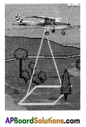
Why do you think maps are useful to armies in times of war?
Answer:
Maps were also in great demand during times of war as armies and airforces needed them.
They use strategy maps to illustrate an organization’s vision, mission, overarching strategies and key goals and initiatives.
![]()
Question 6.
Why were the Greeks and the Romans greatly interested in making maps?
Answer:
The Greeks and after them the Romans were greatly interested in making maps and knowing about places near and far. They wanted to conquer the world, build colonies in far off places and trade with them. e.g.: Alexander, the Greek king.
Question 7.
What is aerial photography?
Answer:
Aerial photography is the technique of taking of photographs of the ground from an elevated position, using aircrafts, helicopters, hot air balloons etc.
Aerial photographs are not maps.
Question 8.
What are satellite imagery?
Answer:
Satellite imageries are the photographs of the earth taken by the artificial satellites launched into the space. These are used in many ways: map making, planning, meteorology, forestry, warfare etc.
![]()
Question 9.
Write the difference between maps and photographs.
Answer:
Maps:
A map is used by geographers to show features that we consider important.
(Or)
A map actually is a model of a place giving those features that the map maker considers to be of importance.
Photographs:
A photograph may not be able to show you the features of a place like a map.
Question 10.
Name the early map makers.
Answer:
The Sumerians, the Babylonians, the Greeks, the Arabs, the Chinese, the Europeans were the early map makers.
Question 11.
How can we read Thematic maps?
Answer:
- A map which focuses on only one aspect is called “Thematic Map”,
e.g.: Political Maps, Physical Maps etc. - We should have the knowledge of different kinds of symbols, colours and patterns which are used on thematic maps.
e.g.: Dark Grey – Mountain Black – Boundary. - Then only we can read Thematic maps.
Question 12.
What are main relief features on the earth?
Answer:
- Relief feature means the high and low places on the surface of the earth.
- The main relief features are: hills, valleys, plateaus, plains, river basins, rocky and sandy places.
![]()
Question 13.
What are called Isolines?
Answer:
The lines which join the places with some common features are called Isolines or Contour lines.
Question 14.
What are the uses of contour lines?
Answer:
Contour lines give an indication of the slope of the land as well as the elevation above sea level.
Question 15.
How did Mt. Everest get its name?
Answer:
In 1802 William Lambton began one of the most important geographical surveys in the world starting from Chennai in the south and culminating in the Himalayas to determine the length of longitude and also the heights of various places. This survey was completed by Sir George Everest. It is this survey that established that Mt. Everest is the highest peak in the world. It was named after George Everest.
Question 16.
What are conventional symbols?
Answer:
The symbols which are used by map makers conventionally are called conventional symbols.
Question 17.
Observe the given picture and write your comment.
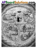
Answer:
This was a model of the world according to the Bible. It is surrounded by oceans and is divided into three continents – Asia, Europe and Africa.
Of these, Asia was considered the largest and the most important as it had Jerusalem which was the birthplace of Jesus Christ. It is therefore also shown on the top.
![]()
Question 18.
Statement:
“All the important features can be shown on a map. So people make different kinds of maps”.
* Read this statement and prepare a question on it.
Answer:
“Why do people make different kinds of maps?”
Question 19.
Why were the Greeks and the Romans greatly interested in making maps?
Answer:
The Greeks and after them the Romans were greatly interested in making maps and knowing about places near and far. They wanted to conquer the world, build colonies in far off places and trade with them.
e.g.: Alexander, the Greek king.
Question 20.
Why do you think that in Idrisi’s map the top side points to the south while in the maps prepared by the Greeks it pointed to the north?
Answer:
In many issues Islamic traditions are different with the rest of the world’s, e.g.: Script.
In the similar way the top side points to the south in Idrisi’s map.
(Or)
While facing towards east, he would have given importance to the right hand side (south) and showed it on the top side of the map.
Question 21.
Appreciate the Babylonian clay tablet world map.
Answer:
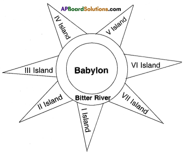 The Babylonian clay tablet was dated from the Persian period. It was flat and round. The inner circle had all the places they knew about. The city of Babylon was shown in the middle. Beyond the inner circle was ‘Bitter river, or ‘Salt water ocean’ in which were seven triangular islands.
Their thought, imagination, map making ability were really appreciable.
![]()
Question 22.
Who invented the latitudes and longitudes and the grid system?
Answer:
Hipparchus (190-120 B.C.) was perhaps the greatest of the Greek astronomers. He devised a method of locating geographical positions by means of latitudes and longitudes. Ptolemy also was a Greek astronomer and mathematician. He lived and worked in Egypt. His work which employed a system of latitudes and longitudes, influenced map makers for hundreds of years. He evolved the science of map-making.
Question 23.
Write the biography of Al Idrisi. (in a few lines)
Answer:
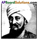
Ash – Sharif Al Idrisi was born in 1099. He was a Muslim geographer, cartographer, Egyptologist and traveller. He lived in Sicily, at the Court of King Roger – II. He spent much of his early life travelling through North Africa and Spain.
Al Idrisi incorporated the knowledge of Africa, the Indian Ocean and the far east gathered by Islamic merchants and explorers and recorded on Islamic maps. He wrote a book ‘A Diversion for the Man Longing to Travel to Far Off Places’. The Tabula Rogeriana’ was drawn by him in 1154 for the Norman King Roger II of Sicily. He died in Sicily in 1165/1166.
Question 24.
Observe the following paragraph and answer the given questions.
Relief feature means the high and low places on the surface of the earth. The main relief features are: hills, valleys, plateaus, plains, river basins, rocky and sandy places. Since the maps are flat we cannot show the height on them. We, therefore, use a special symbol for this called contours or contour lines. Contours are lines on the map joining places of same height – measured from the sea level. In other words, all places on a contour line will have the same height from the sea level. Contour lines are also called isolines – lines joining places with some common features.
1. What is meant by Relief feature?
Answer:
Relief feature means the high and low places on the surface of the earth.
2. What are the main relief features?
Answer:
The main relief features are hills, valleys, plateaus, plains, river basins, rocky and sandy places.
3. Why can we not show the heights of the maps?
Answer:
Since the maps are flat we cannot show the height on them.
4. Special symbols are called contour lines.
5. Contours are lines on map joining places of same height measured from the sea level.
6. Contour lines are also called isolines.
7. What are isolines?
Answer:
Isolines are the lines which join the places with some common features.
![]()
Question 25.
Observe the given information and answer the following questions.
| Names of Famous Explorers | Their Nationality | Their Lifespan | Their Voyage of Exploration |
| 1) Marcopolo | Italian | 1254- 1324 | China and Asia |
| 2) Ferdinand Magellan | Portuguese | 1480- 1521 | First voyage around the world. |
| 3) Christopher Columbus | Italian / Spanish | 1451 – 1506 | America, the new world. |
| 4) Vasco-da-Gama | Portuguese | 1469-1524 | Ocean route from Portugal to east. |
| 5) Bartholomeu Dias | Portuguese | 1457- 1500 | Voyage around the Cape of Good Hope on the southern most tip of Africa. |
1. Who were the Protuguese explorers?
Answer:
Magellan, Vasco-da-Gama and Bartholomeu Dias were the Portuguese explorers.
2. What do you know about Marcopolo?
Answer:
Marcopolo was an Italian explorer. He explored China and Asia.
3. Who discovered America?
Answer:
Christopher Columbus discovered America.
4. What was the lifespan of Magellan?
Answer:
His lifespan of Magellan was 1480 – 1521. (41 years)
5. Who made his first voyage around the world?
Answer:
Ferdinand Magellan.
![]()
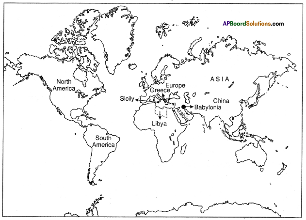
Question 26.
Locate the following on the given world map.
- Present place of Babylonians / Sumarians
- Greece
- Sicily
- Libya
- Asia
- Europe
- Arabia
- China
- North America
- South America
Answer:
![]()
Question 27.
Observe the given map.
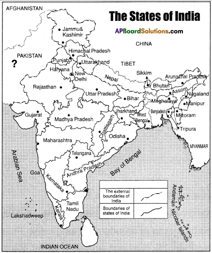
Now answer the following questions.
1. What are the islands in the Arabian sea
Answer:
Lakshadweep.
2. ![]() This indicates
This indicates
Answer:
External boundaries.
3. What is the scale of the map?
Answer:
1 cm = 200 kms.
4. Name any state on east coast.
Answer:
Odisha, Andhra Pradesh.
(you can write any one)
5. Name any state on the west coast.
Answer:
Gujarat.
Question 28.
Observe the given picture and write down your opinion on Mercator projection.
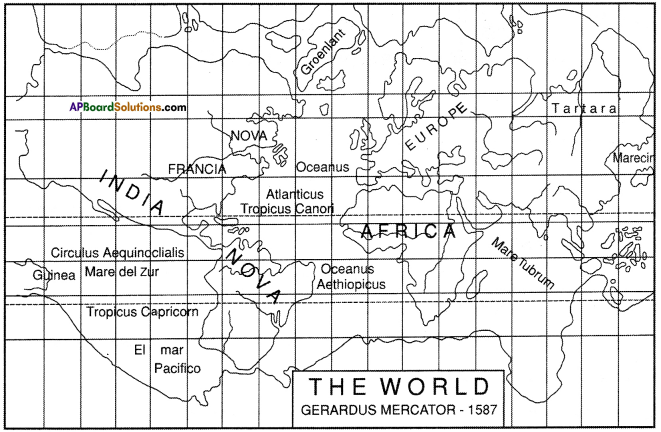
Answer:
- Gerardus Mercator was a Dutch geographer and cartographer.
- The Mercator projection distorts the size and the shape of large objects, as the scale increases from the equator to the poles, where it becomes infinite,
e.g.: 1) Greenland takes as much space on the map as Africa. In reality Africa’s area is 14 times greater than that of Greenland. Greenland is comparable to Algeria only.
2) Alaska – Brazil - Finland – India.