AP State Syllabus 7th Class Social Important Questions 1st Lesson Reading Maps of Different Kinds
Question 1.
What are contour lines?
Answer:
The lines which are joining the places with equal heights are called contour lines.
Question 2.
Write two uses of a physical map.
Answer:
- A physical map is one that shows the physical landscape features of a place.
- Mountains and elevation changes are usually shown with different colors and shades to show relief.
- Normally on physical maps, green shows lower elevations while browns show
high elevations.
![]()
Question 3.
What is a map? What are the different types of maps?
Answer:
A map is a representation of the total or a part of the earth’s surface drawn on flat surfaces.
Maps are of many types. They are political maps, physical maps, thematic maps, weather maps, railway route maps and population maps, etc.
Question 4.
Describe the contour lines. (or)
Write any two characteristics of the counter lines.
Answer:
- A contour is a line joining the places with equal heights.
On the map of Nippur we would have seen that there is a line passing through the village, this is. the 50-meter contour line.
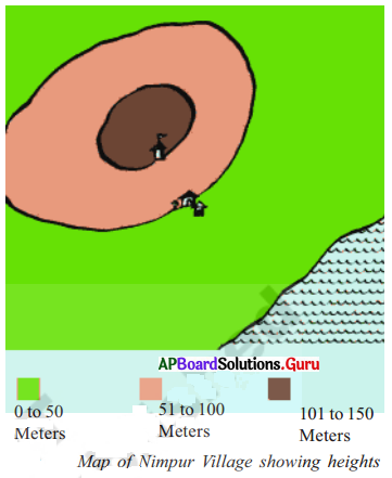
- All places on this line will have the same height of 50 meters.
- Contour lines will be in irregular shape depending upon the landform.
- These can’t cut with each other.
- The distance between two contour lines will depend upon the landscape.
- If the land has a steep climb, then the contour lines will be near to each other.
- If the slope of the land is gentle, then the contour lines will be quite far from each other.
![]()
Question 5.
What are physical maps?
Answer:
They show natural features of the earth like mountains, plateaus, plains, rivers, oceans, etc., and depict the heights of places.
Eg: Physical map of the world.
In these maps, we will usually find different parts of the land coloured in green, yellow, brown.
Question 6.
How do symbols help in reading maps?
Answer:
It is not possible to draw a map in the actual shape and size with different features such as buildings, roads, rivers, bridges, trees, railway lines, etc. So they are shown by using certain letters, shades, colours, pictures, and lines. These symbols give a lot of information and help in reading maps. These symbols are called conventional symbols.
Question 7.
What is a map? Describe its major features.
Answer:
It is a representation of the Earth’s surface or its part on a flat surface according to scale. Maps are useful for various purposes. A map shows a large area on a small scale.
- It gives much information as a book.
- Maps can be made for different purposes.
- A collection of these maps can give detailed information.
Question 8.
Observe the following and answer the given questions.
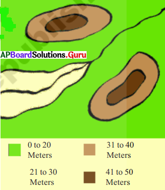
a. Mark the direction of flow of the river.
Answer:
From North East to South West.
![]()
b. The height of the lowest land is between ………. meters and ………… meters.
Answer:
Zero; Twenty.
c. There are two high points on this map. What are their heights?
Answer:
Their heights are 21 to 30 meters; 41 to 50 meters.
Question 9.
Look at a few maps in later chapters of this book and list out the objects in the given map in the following table:
Answer:
| Print Symbol | Line Symbol | Area Symbol |
| 1. Temple | 1. Road | 1. Play ground |
| 2. Delhi | 2. River | 2. Play ground |
| 3. Kalyani | 3. Fluctuating frontier | 3. Chola empire |
Question 10.
Observe the following and answer the questions.
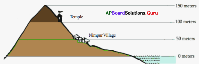
a. How many meters above sea level is the temple?
Answer:
The temple is 100 meters above sea level.
b. Which settlement was located 50 meters above Sea level.
Answer:
Nimpur village is located 50 meters above sea level.
c. How many meters above sea level is the top of the hill?
Answer:
The top of the hill is 150 meters above sea level.
d. Tell whether Nimpur would be submerged if sea waters were to flood up to 30 meters?
Answer:
No, the village is 50 meters above sea level.
![]()
Question 11.
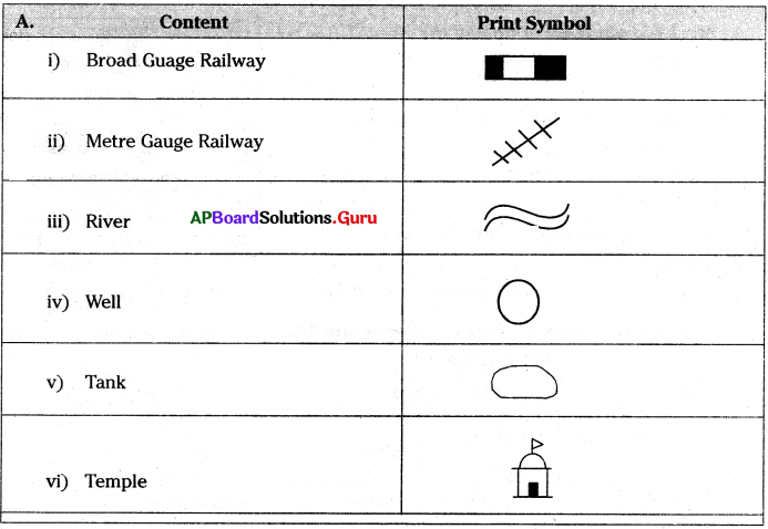
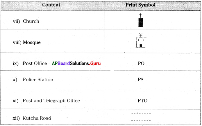
Draw the symbols of the following.
- Broad Gauge Railway
- Metre Gauge Railway
- River
- Well
- Tank
- Temple
- Church
- Mosque
- Post Office
- Police Station
- Post and Telegraph Office
- Kutcha Road.
Answer:
Question 12.
Read the following para and answer the questions.
The point, Line, Area: We use symbols to show any physical object on the map.
If we are asked to show Delhi in India map, we will mark a point ![]() and label it j as Delhi, To show the river Godavari, we draw a line
and label it j as Delhi, To show the river Godavari, we draw a line ![]() along its course, for the Railway line we will draw a track line
along its course, for the Railway line we will draw a track line ![]() to represent it. In the Andhra Pradesh map, if we want to show the area of Krishna or Guntur district, we demarcate its boundary and mark it with some color or pattern, which is known as a real symbol. Thus all physical objects are shown on the map with the help of a point, line, or area symbol.
to represent it. In the Andhra Pradesh map, if we want to show the area of Krishna or Guntur district, we demarcate its boundary and mark it with some color or pattern, which is known as a real symbol. Thus all physical objects are shown on the map with the help of a point, line, or area symbol.
1. What are the symbols we use to show any physical object on the map?
Answer:
The point, Line, Area.
2. When do we use ‘![]() ’ symbol?
’ symbol?
Answer:
We use ![]() symbol to mark a city on the map.
symbol to mark a city on the map.
3. When should we draw a line?
Answer:
To show a river on a map, we should draw a line.
4. How can we show the area of Krishna or Guntur in a map?
Answer:
If we want to show the area of Krishna or Guntur district, we demarcate its boundary and mark it with some colour or pattern, which is known as a real symbol.
![]()
Question 13.
Read the following para and answer the questions.
Contour Lines
A contour is a line joining the places with equal heights. On the map of Nimpur you would have seen that there is a line passing through the village, this is the 50-meter contour line. All places on this line will have the same heights of 50 meters. Contour lines will be in irregular shape depending upon the landform. These cannot cut with each other. The distance between two contour lines will depend upon the landscape. If the land has a steep climb, then the contour lines will be near to each other. If the slope of the land is gentle, then the contour lines will be quite far from each other.
1. What is a contour?
Answer:
A contour is a line joining the places with equal heights.
2. What is the contour line on the map of Nimpur?
Answer:
On the map of Nimpur we can see a line passing through the village. This is the 50-meter contour line.
3. What is the shape of contour lines?
Answer:
Contour lines will be in irregular shape depending upon the land form.
4. When will be the contour lines near to each other?
Answer:
If the land has a steep climb, then the contour lines will be near to each other.
5. When will be the contour lines far from each other?
Answer:
If the slope of the land is gentle, then the contour lines will be quite far from each other.
Question 14.
How can we represent the heights of land on flat paper?
Answer:
Drawing of Nimpur Village:
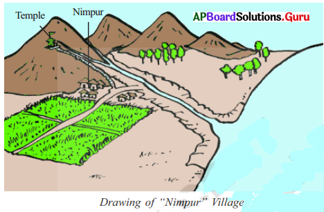
In Atlas, we can find some maps called ‘Physical Maps’. In these maps, we will find different types of land colored in green, yellow or brown. Actually, they show the variety of landforms and depict the heights of places. Here the height of the hills hides what is behind them. A map has to show all places without hiding them. One way in which we can show heights on maps is through the use of color.
![]()
Question 15.
Observe the following map and answer the given questions.
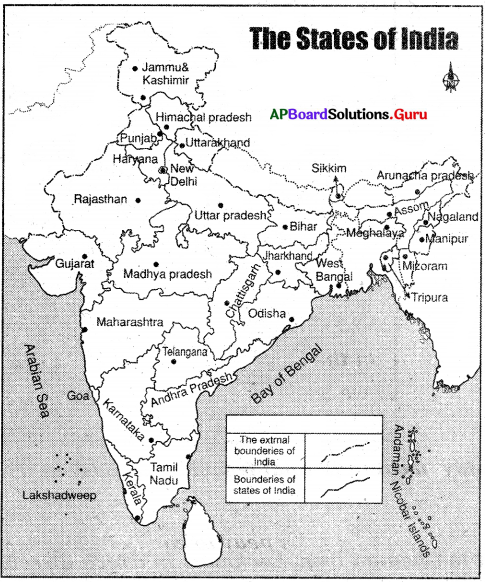
a. Look at the symbols shown on the map. Now try to find out the boundary of Andhra Pradesh. Trace your finger over the entire length of the boundary.
Answer:
Self exercise.
b. Draw the symbol for the boundary of a state and the symbol for the boundary of India (international boundary) in your notebook.
Answer:
Self exercise.
c. Can you make a list of states which lie to the North, South, West of Andhra Pradesh? What lies to the East of the state?
Answer:
North: Telangana, Chattisgarh
West: Karnataka
South: Tamilnadu
East: Bay of Bengal
d. In class VI you have also learned to measure distances between places with the help of the ‘scale’ given in the map. Now try to find out the distance between Hyderabad and various state capitals like Jaipur, Imphal, Gandhinagar, and Tiruvananthapuram.
Answer:
1. Jaipur: 1443 km.
2. Imphal: 2854 km
3. Tiruvananthapuram: 1315 km
4. Dehradun: 1677 km
5. Bengaluru: 562 km
6. Bhubaneshwar: 1075 km
7. Kolkata: 1516 km
8. Chennai: 688 km
9. Delhi: 1499 km
![]()
Question 16.
Hang a political map of India in the class. Look at the map carefully and answer the following questions:
i) Krishna Reddy went to Bhopal from, Hyderabad. In which direction did he travel?
Answer:
North.
ii) Ashok went to Chennai from Lucknow. In which direction did he travel?
Answer:
South
iii) Regina went to Bhubaneshwar from Mumbai. In which direction did she travel?
Answer:
East
iv) Weprechu went to Jaipur from Kohima. In which direction did he travel?
Answer:
West
Note: Make more such questions and ask each other students’ interactions.
![]()
Question 17.
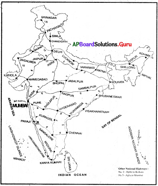
Read the map given below and answer the following questions.
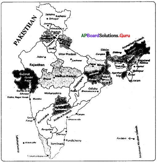
a) Name the city which is the common capital of two Northern states.
Answer:
Chandigarh.
b) Mention one state that shares its boundaries with Pakistan.
Answer:
Rajasthan, Gujarath, Punjab, Jammu & Kashmir.
c) Mention one state on Eastern Coast.
Answer:
Odisha, Andhra Pradesh, Tamilnadu, West Bengal.
d) Mention two states that are sharing their boundaries with Andhra Pradesh.
Answer:
Tamil Nadu, Karnataka, Telangana Chattisgarh, and Odisha.