These AP 6th Class Social Important Questions 3rd Lesson Maps will help students prepare well for the exams.
AP State Syllabus 6th Class Social Important Questions 3rd Lesson Maps
Question 1.
When a map is useful?
Answer:
When we want to study the Earth horizontally as a part, such as a country, state, district, town, village, and world as a whole maps are useful.
Question 2.
What is a map?
Answer:
A map is a representation of the whole Earth or a part of it, on a flat surface according to its proportionate scale.
![]()
Question 3.
What are the four cardinal directions and what are the components of a map?
Answer:
There are four major directions: North, East, West, South. They are called cardinal directions.
Components of a map are
- Distance,
- Direction,
- Symbols and
- Colours
Question 4.
What do you mean by the term the scale of the map?
Answer:
The scale of the map is the ratio between the actual distance of the ground and the distance shown on the map. Ex: 1 cm : 10 km.
Question 5.
How are maps prepared?
Answer:
Usually, maps are prepared in such a manner that the north direction is at the top of the map. Among the four directions, North is treated as the Principal direction. The south side is at the bottom. So the east side is on the right and the west side is on the left.
Question 6.
Define a sketch.
Answer:
A drawing that is drawn without scale and directions is called a sketch. A sketch is a drawing mainly based on memory and spot observation.
![]()
Question 7.
What are the intermediate directions? How they are useful?
Answer:
North East (NE), South East (SE), South West (SW) and North West (NW) are the intermediate directions. With the help of these intermediate directions, we can locate a place more accurately.
Question 8.
What is a scale? How is it useful?
Answer:
A scale is one of the main components of a map. On a map, we can’t show the actual distance between two places. We use a scale to show the actual distance on the ground by reducing it on a map. We can show the distance in proportion with the help of a scale.
Question 9.
Why symbols are used in the maps?
Answer:
With the use of symbols, maps can be drawn easily. With the Symbols, maps are simple to read. Symbols give a lot of information in a limited space. Even if we don’t know the language of an area we can know the information from maps with the help of symbols.
Question 10.
What are the neighbouring countries that share the land with India?
Answer:
Neighbouring countries that share the land with India are Pakistan, China, Nepal, Bangladesh, Bhutan and Myanmar.
Question 11.
Name different types of maps.
Answer:
Three types of maps are used frequently. They are :
- Political map,
- Physical map and
- Thematic map.
![]()
Question 12.
What does a political map show?
Answer:
A political map shows villages, cities, towns, districts, states with their capitals and countries with their capitals boundaries.
Question 13.
What does a physical map show?
Answer:
A physical map shows the physical features such as mountains, plateaus, plains, oceans, rivers and deserts.
Question 14.
What does a thematic map show?
Answer:
A thematic map shows the physical distribution of specific features such as land use, temperature, rainfall, population, soils, natural vegetation, crops, minerals, industries, railways, roads and waterways.
Question 15.
How many continents are there? What are they?
Answer:
There are 7 continents. They are Asia, Africa, North America, South America, Australia, Europe and Antarctica.
Question 16.
How many oceans are there? What are they?
Answer:
There are 5 Oceans. They are the Pacific Ocean, Indian Ocean, Arctic Ocean, Antarctic Ocean and the Atlantic Ocean.
![]()
Question 17.
Expand GPS.
Answer:
Global Positioning System.
Question 18.
How web-based maps are useful?
Answer:
Web-based maps provide detailed information about geographical regions and sites around the world. They offer aerial and satellite views of many places.
Question 19.
What are large scale maps?
Answer:
Large scale maps represent small areas. They can be divided into Cadastral maps and Topographical maps. Cadastral maps show the individual property. Topographical maps show detailed surface features.
Question 20.
What are small scale maps?
Answer:
Small scale maps represent large areas like World, Continents or Countries. They are of two types – Wall maps and Atlas maps.
![]()
Question 21.
What is the difference between Globe and Map?
Answer:
- Globe is a model of Earth.
- Globe is useful to study the shape of the Earth as a whole.
- We can’t see details of a country/place in the Globe.
- We can observe all particulars in Maps.
- There are separate maps like Thematic maps, Political maps and Physical maps. We can use the specific map for a particular purpose.
Question 22.
What are small scale maps?
Answer:
- Small scale maps represent large areas, i.e., World, Countries and Continents.
- They are two types: One is Wall maps and the other is Atlas maps.
- Wall maps are larger in size than the Atlas.
- Small scale maps are used for teaching.
Question 23.
Observe the picture and answer the questions.
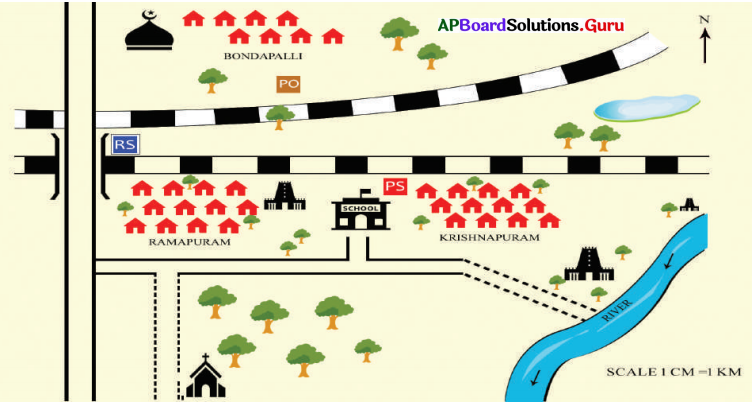
1. Where is the school situated?
Answer:
The school is situated in between Ramapuram and Krishnapuram.
2. Where the pond is located?
Answer:
The pond is located in the North-East direction.
3. Where is the masjid located?
Answer:
The masjid is located in the North-West direction.
4. What is RS. Shown in the picture?
Answer:
It is a Railway station.
5. ![]()
What does this symbol denote?
Answer:
Broad Gauge Railway Line.
![]()
Question 24.
Based on the content or purpose maps can be classified into three types: 1. Political Map 2. Physical Map 3. Thematic Map
i) How many types of Maps are there? What are they?
Answer:
There are three types of Maps.
They are Political, Physical and Thematic Maps.
ii) What is the Political map?
Answer:
Maps showing villages, cities, towns, districts, states and countries with their boundaries are called Political Maps.
iii) What is the Physical map?
Answer:
Physical maps show physical features such as mountains, plateaus, plains, oceans, rivers, deserts, etc.
Question 25.
Observe the map and answer the following questions.
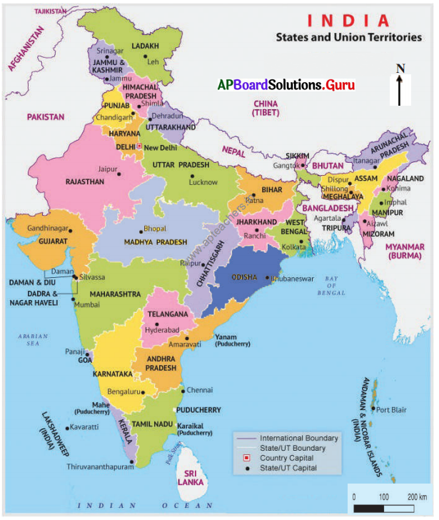
1. What is the country in the Southern direction to us?
Answer:
Sri Lanka.
2. What is the capital of Ladakh?
Answer:
Leh.
3. What is the country in the North-West direction?
Answer:
Afghanistan.
4. What is the capital of the Andaman and Nicobar islands?
Answer:
Port Blair
5. What is the capital city of Madhya Pradesh?
Answer:
Bhopal.
![]()
Question 26.
Observe the symbols printed below and answer the following.
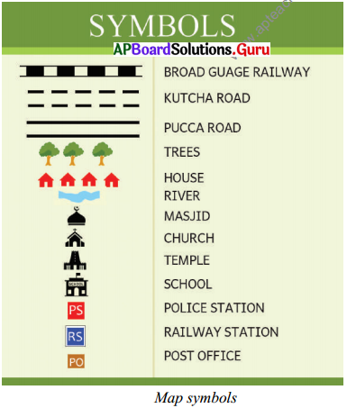
a) Draw the symbols for various religious places from the table.
Answer:
![]()
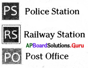
b) Write the Symbols with Letters from the table.
Answer:
c) Draw different roads.
Answer:

d) Draw any other symbol know to you.
Answer:
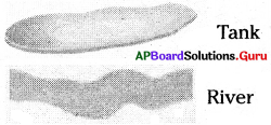
Question 27.
People are often using other than traditional maps comment.
Answer:
Yes. People are often using other than conventional maps. They are web-based maps. They provide detailed information about different geographical regions. They also offer aerial and satellite views of many places.
Question 28.
Do you think that India and its surrounding countries are moving friendly?
Answer:
- Indian surrounding countries are Pakistan, Afghanistan, China, Nepal, Bhutan, Bangladesh and Myanmar.
- China and Pakistan are always trying to quarrel with India at the border.
- Now, Nepal is also ready to follow the same path.
- India always tries for peace and prosperity with border countries, but in vain.
![]()
Question 29.
Why should we appreciate the cartographers?
Answer:
- We must appreciate the cartographers for their contribution to making maps.
- Man’s thoughts are like in the story “Frog in the well”.
- People of every country thought that their country is the centre point in the world.
- When cartographers made maps, people realised the real world.
Question 30.
Read the below map and answer the following questions.
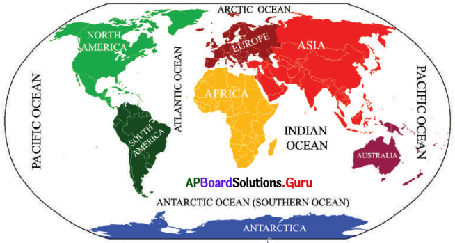
a) Name the continents that have a boundary with the Atlantic Ocean.
Answer:
North America, South America, Europe and Africa.
b) Name the Oceans that are around the poles.
Answer:
- The Arctic Ocean is around the North pole.
- The Antarctic Ocean is around the South pole.
c) What is the biggest Ocean on the Earth.
Answer:
The Pacific Ocean is the biggest ocean on Earth.
d) What are the continents that have their boundaries with the Indian Ocean?
Answer:
Africa, Asia and Australia are the continents that have their boundaries with the Indian Ocean.
e) The name of a continent and an ocean are similar, what are they?
Answer:
Ocean: Antarctic Ocean
Continent: Antarctica.