Students can go through AP Board 7th Class Social Notes 3rd Lesson Learning Through Maps to understand and remember the concept easily.
AP Board 7th Class Social Notes 3rd Lesson Learning Through Maps
→ Maps make our travel easier and accurate in guiding us towards the destination.
→ Vasco Da Gama reached Calicut in 1498 AD.
→ Magellan was the first person who voyaged across the Globe.
→ The Sailors and travellers had a great contribution in map – making.
→ The Sumerians, Babylonians used clay tablets as maps.
→ The Greek map makers Anaximander, Hacataeus, Herodotus prepared maps from arranging the places from West to East.
→ Gerardus Mercator introduced a method called projection that brought a great change in map making.
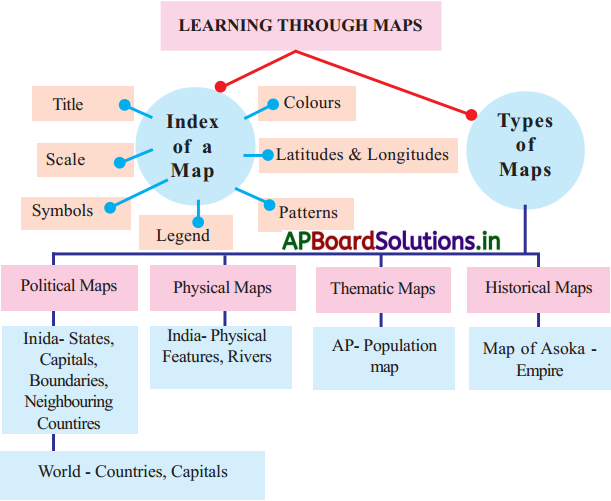
→ Scale, directions, symbols and colours are parts of a map.
→ Title of the map says about the theme or subject of the map.
![]()
→ Colours used in physical maps, thematic maps convey specific information.
→ Map makers use symbols to show their location in a map.
→ Maps are the key resources to know the details of a place.
→ Political map shows the administrative units, neighbouring countries, boundaries, capitals etc.
→ The map that shows the information about the physical features of a place like mountain ranges, hills, plateaus, plains, rivers, deserts, lakes, highlands etc. is called a physical map.
→ The imaginary lines that connect the places of equal heights are known as Contour lines.
→ Maps that are prepared for a special purpose or on theme are called thematic maps.
→ The map that shows historical details are known as Historical maps.
→ Index of a Map : A list of some kind of feature shown on the map, which either helps users to interpret the map, or to locate.
→ Types of Maps : Maps are classified based on the scale theme/content/ concepts and methods of preparation.
Ex:
- Political map
- Physical map.
→ Political Maps : Political map shows the administrative units, neighbouring countries, capitals etc.
→ Physical Maps : The map that shows the information about the physical features of a place like mountain ranges, hills, plateaus, plains, rivers, deserts, lakes, high lands etc. is called a physical map.
→ Thematic Maps : Maps that are prepared fora special purpose or on theme are called thematic maps.
→ Historical Maps : The map that shows historical details are known as Historical maps.
![]()
1. Spatial Information : Information with direct or indirect reference to a specific location.
2. Cartographer : A person who draws maps.
3. Edicts : Inscriotions; The official order or proclamation issused by a person in authority.
4. Toposheets : Maps that represent the natural and cultural features of a particular area.
5. Union Territories : An administrative unit of our country, governed by the central goverment.
6. Conventional Symbol : These are the small pictures that stand for different features on a map used by Survey of India.
7. Voyage : A long journey involving travel by sea or in space.
8. Drainage : The flow of water, particularly the river systems.