SCERT AP Board 9th Class Social Solutions 1st Lesson Our Earth Textbook Questions and Answers.
AP State Syllabus 9th Class Social Studies Solutions 1st Lesson Our Earth
9th Class Social Studies 1st Lesson Our Earth Textbook Questions and Answers
Improve Your Learning
Question 1.
Look at the map of India in an Atlas and identify latitude and longitude for the following places.
a) Kanyakumari ………………. and ………………. .
b) Imohal ………………. and ………………. .
c) Jaisalmer ………………. and ………………. .
d) Pune ………………. and ………………. .
e) Patna ………………. and ………………. .
Answer:
a) Kanyakumari : 77°36′ E longitude and 8°35′ N latitude
b) Imphal : 93°58′ E longitude and 24°44′ N latitude
c) Jaisalmer : 26°55′ N latitude and 70°54′ E longitude
d) Pune : 18°32′ N latitude and 73°52’E longitude
e) Patna : 27°34′ N latitude and 81°46′ E longitude
Question 2.
Identify the words that match with Latitude and Longitude (parallel lines, vertical lines, horizontal lines)
Answer:
Latitudes are horizontal and parallel lines. Longitudes are vertical lines.
Question 3.
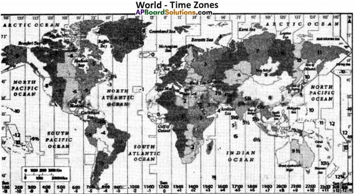
Look at the world map of time zones in the Text page 13.
a) If you travel from Vijayawada to Paris to which time zone are you moving?
b) If you are travelling from Hyderabad to Tokyo which time zone are you moving? ……………………… .
Answer:
a) – 5.30 hrs time zone
b) – 3.30 hrs time zone.
![]()
Question 4.
Why is it difficult to study the formation of the earth and its structure?
Answer:
Earth formed around 4.54 billion years ago by accretion from the solar nebula. Nearly all branches of natural science have contributed to the understanding of the main events of the earth’s past. The age of the earth is approximately one-third of the age of the universe. Biological and geographical change has been constantly occurring on our planet since the time of its formation. The process of plate tectonics has played a major role in the shaping of earth’s oceans and continents as well as the life on it.
It took us years of scientific investigation and analysis of data to form an understanding of the interiors of the earth. The main reason for this is that even the deepest mines we have dug do not go beyond a few kilometers under the surface while the radius or the distance to the centre of the earth is over 6000 kilometers.
Thus it is very difficult to study the formation of the earth and its structure.
Question 5.
Read the paragraph under the heading of “Internal structure of the earth” and answer the question.
| Internal Structure of the Earth : Let us look at the internal structure of the Earth we live on. We can see the continuity from the early days of the formation of the earth as we try to look deep inside the Earth! It took us years of scientific investigation and analysis of data to form an understanding of the interior of the Earth. The main reason for this is that even the deepest mines we have dug do not go beyond a few kilometres under the surface while the radius or the distance to the centre of the earth is over 6000 kilometres! |
How can you say the earth is still very active?
Answer:
- The matter deep inside the mantle shoots up through volcanoes and fissures on ocean floors.
- In many regions on the earth part of the earth’s crust enters into the mantle and once again becomes molten.
- The crust is still being changed by earthquakes, volcanoes, subduction of land and rise of mountains due to the processes happening deep down the earth.
- This constant process of formation and destruction of the earth’s crust explains the fact that the earth is still very active.
![]()
Question 6.
What is a grid and how does it help us?
(OR)
Write any two uses of the ‘Grid system’ located on the globe.
Answer:
Grid : A grid is a sqaure or a rectangle that is formed between when two latitudes and longitudes out across each other. In other words the network of latitudes and longitudes drawn on the globe is called a ‘grid’.
Uses of grid:
1. Network of latitudes and longitudes is called a Grid.
2. Uses of a grid :
a) To locate a place
b) How hot or cold it would be there,
c) To know the time.
Question 7.
Differentiate between
a) Local and Standard time
b) Equator and Prime meridian.
Answer:
a) Difference between Local and Standard time :
| Local Time | Standard Time |
| 1) The time of a place when the mid day sun is over head is called local time. | 1) The local time of the standard meridian of a country is called a standard time. |
| 2) It changes from place to place. | 2) It remains same for that particular country. |
| 3) The place on the same longitude has the same local time. | 3) The place on the same longitude has the different standard time. |
Example: If the 1ST is 12.00 noon, the local of Mumbai is 39 minutes – 1ST = 11.21 minutes a.m.
Since Mumbai is on 72°82′ east longitudes, it is 9°45′ behind the 82°30′. Thus the local time of Mumbai is 9.45 x 4 = 38 minutes.
b) Differences between Equator and Prime meridian :
| Equator | Prime meridian |
| 1) Equator is 0° latitude. | 1) Prime meridian is 0° longitude. |
| 2) Equator divides the earth into parts, i.e. Northern hemisphere and Southern hemisphere. | 2) The Prime meridian divides the earth into two equal parts i.e., Eastern hemisphere and the Western hemisphere. |
| 3) Equator is a circle. | 3) Prime meridian is a semi-circle. |
| 4) It is an imaginary line that runs east and west around the exact middle of the globe. (A horizontal line) | 4) It is an imaginary line running from pole to pole and passing through Greenwich, England. (A vertical line) |
Question 8.
If every state follows its local time then what problems will rise?
Answer:
If every state follows4ts local time, a lot of serious problems would rise. Some of them are being discussed hereunder.
- At the time of national calamities and disasters, it is very difficult for the national government to make necessary emergency announcement.
- At the time of wars and national emergency, it is very difficult for the national government to alert all the defensive forces stationed in all the state capitals and the naval forces of all the coastal states.
- It is very difficult for Televisions and Radios to follow a single schedule to broadcast their programmes.
- Railways faces a difficult problem in preparing a timetable for its trains that travel through many states.
![]()
Question 9.
With the help of your teachers find out the standard meridian of given countries.
1. Nepal
2. Pakistan
3. Bangladesh
4. England
5. Malasiya
6. Japan
Answer:
1. Nepal : 88°45’East is the Standard Time Meridian of Nepal
2. Pakistan : 74°22′ East .
3. Bangladesh : 90°24′ East
4. England : 0°07′ West
5. Malaysia : 100° East
6. Japan : 90° East
Question 10.
Make a thought provoking poster on the earth’s protection.
Answer:

9th Class Social Studies 1st Lesson Our Earth InText Questions and Answers
Question 1.
Tick the factors which cause the formation of seasons on the earth : (Text Book Page No. 3)
a) Daily rotation of the earth on its axis.
b) Monthly movement of the Moon around the Earth.
c) Rotation of the Sun on its axis.
d) Revolution of the Earth around the Sun.
e) Tilt of Earth’s axis of rotation to its orbital plane.
f) Spherical shape of the Earth.
g) Earth’s distance from Sun during the annual revolution.
Answer:
d) (✓)
e) (✓)
g) (✓)
Question 2.
We cannot hope to travel to the mantle to study it. But we can study substances from the mantle. Can you tell what these substances would be and how we can get them? (Text Book Page No. 5)
Answer:
1) The thickness of the mantle is 100 – 2900 kms. So we cannot hope to travel to the mantle to study it.
2) Interestingly the matter from the deep inside the mantle shoots up through volcanoes and fissures on ocean floors and cools down to form the earth’s crust.
3) Thus by studying the lava or magma or the substances brought up through the fissures, we can study the substances from the mantle.
Question 3.
When it is 12 noon in Greenwich (0°), what is the local time at: (Text Book Page No. 12)
a) Mumbai (73° E)
b) Chicago (87°30′ W)
c) Sydney (151° E)
Answer:
a) Mumbai (73° E) :
Local time at Mumbai is : 73 × 4 = 292 minutes, i.e. 4 hours 52 minutes. That means the local time at Mumbai is 4 hours 52 minutes after 12 noon i.e., 12.00 + 4.52 = 4.52 p.m.
b) Chicago (87°30′ W):
Local time at Chicago is : 87°30′ × 4 = 350 minutes, i.e. 6 hours 50 minutes. That means the local time at Chicago is 6 hours 50 minutes less than 12.00 noon at Greenwich. i.e. 12.00 – 6.50 = 5.10 a.m.
c) Sydney (151° E): Local time at Sydney is 151° × 4 = 604 minutes, i.e. 10 hours 4 minutes before Greenwich time.
That means the local time at Sydney is 12.00 + 10.04 = 10.04 p.m
![]()
Question 4.
Why do you think people today are curious to know about the secrets of distant stars and galaxies and the beginning of the universe? (Text Book Page No. 2)
Answer:
Today people are curious to know about the secrets of the distant stars and galaxies and the beginning of the universe
a) to understand the stars that shine there.
b) to understand the sun, the moon and the planets which keep moving across the sky.
c) to understand what are these and in what way they are related to us and how they affect us.
d) to know how they move and work.
e) to know whether there is any life on any other planet.
Question 5.
Swathi works for a call centre in Hyderabad. Her clients are in the U.S.A. She answers clients’ questions about the computer problems. She always works during the night. Why is this? Use geography to find out! (Text Book Page No. 12)
Answer:
Indian Standard Time is the time observed in India. Its time offset is UTC + 5.30.
United Standard Time is the Central Standard Time. Its time is GMT – 6.00. Thus there is a difference of 11½ hours between Indian Standard Time and American Standard Time. Thus if it is day time in America, in India it is night time. If an American client asks Swathi a question at 11 am in America, Swathi has to answer the same at 10.30 p.m the same day. Thus Swathi should always work at night to answer his clients from the U.S.A.
Question 6.
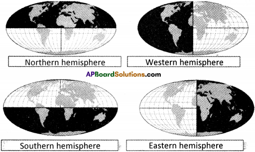
In earlier classes we have studied about hemisphere. Let us revise it in the image below. (Text Book Page No. 8)

With the help of the above maps complete the following table.
| Hemisphere | Continents |
| Northern hemisphere | |
| Western hemisphere | |
| Southern hemisphere | |
| Eastern hemisphere |
Answer:
| Hemisphere | Continents |
| Northern hemisphere | Asia, Europe, North America |
| Western hemisphere | North America, South America, Antarctica |
| Southern hemisphere | South America, Africa, Antarctica, Australia |
| Eastern hemisphere | Asia, Africa, Australia, Antarctica, Europe |
Question 7.
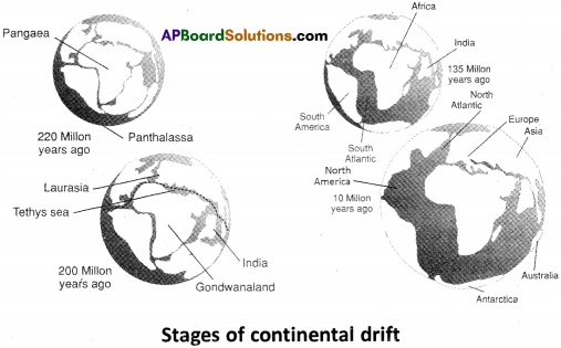
Look at the following pictures. (Text Book Page No. 6)

Now answer the following questions.
1. Look carefully at the map of the world, do you find some continents looking as if they are two pieces of a jigsaw puzzle? Name those continents. (Text Book Page No. 7)
Answer:
By observing the maps of the world from 220 million years ago up to the present world, we can find the following continents look as if they are two pieces of jigsaw puzzle. They are :
1) North America and North West Africa.
2) South America and Western Africa.
3) Nothern Africa and Eurasia.
4) Eastern Africa and India.
5) South Eastern Africa and Antarctica.
6) Antarctica and Australia.
2. In which direction Australia is moving?
Answer:
Australia is moving in eastern direction.
3. In which direction India is moving?
Answer:
India is moving in northern direction.
Question 8.
Look at the following map. (Text Book Page No. 12)

Using your Atlas, find out how many standard time zones these countries have :
a) U.S.A
b) Australia
c) Russia
d) Japan
e) Zimbabwe and
f) Chile.
Answer:
a) U.S.A :
The United States uses nine standard time zones. From east to west they are Atlantic Standard Time, Eastern Standard Time, Central Standard Time, Mountain Standard Time, Pacific Standard Time, Alaskan Standard Time, Hawai – Aleutian Standard time, Samoa Standard Time and Chamorro Standard Time.
b) Australia :
Australia uses three standard time zones.
a) Australia Eastern Standard Time (GMT + 10)
b) Australia Central Standard Time (GMT + 9½)
a) Australia Western Standard Time (GMT + 8)
c) Russia :
There are 9 time zones in Russia.
a) Kaliningrad Time – UTC + 3
b) Moscow Time – UTC + 4
c) Yaketerinburg Time – UTC + 6
d) Omsk Time – UTC + 7
e) Krasnoyarsk Time – UTC + 8
f) Irkutsk Time – UTC + 9
g) Yakutsk Time – UTC + 10
h) Vladivostok Time – UTC + 11
i) Magadan Time – UTC + 12
d) Japan :
Japan Standard Time – UTC + 9
e) Zimbabwe :
Zimbabwe uses Central Africa Time zone : UTC + 2h standard time
f) Chile :
Since Chile uses daylight saving time, in total 4 time zones are used.
Question 9.
Initially people thought that the earth was in the centre of the universe and human beings the most important creation. What difference does it make to us to know that we are a small insignificant speck in this vast universe? (Text Book Page No. 2)
Answer:
The earth we live on seems big and very important to us. But in the universe as a whole, it is tiny and very insignificant speck of rock. To put things into perspective earth is just a small planet in the solar system, part of a family of bodies that circle round the sun. The sun is just one of billions of stars that makes up our galaxy, and this galaxy is just one of billions that make up a universe bigger than most of us can imagine.
Question 10.
Do you think the Earth was created suddenly or do you think it was formed by long drawn and complex processes? (Text Book Page No. 4)
Answer:
The Earth began to form around four and a half billion years ago. The earth has reached its present form through several phases but not created suddenly.
- It began as a ball of swirling dust and clouds and passed through a molten stage.
- The molten Earth was very hot and was constantly bombarded by massive rocks and other materials from the space. In this way the size of the earth grew.
- When the earth was so hot and in liquid form the heavier particles went to the bottom and formed core and the mantle.
- The lighter particles cooled at the top and formed the crust.
- While the earth’s interior was cooling, it contracted and outer crust wrinkled forming ridges (i.e., mountains) and basins (i.e., oceans)
- It took a long time for the air we breathe to develop.
Thus we can say that the earth was not created suddenly but formed through several phases.
![]()
Question 11.
Some people believe that our being on this earth is the result of a series of fortuitous accidents – it is quite possible that there may not have been any life on the earth. Do you agree? Give your reasons. (Text Book Page No 4)
Answer:
Yes, the earth’s creatures have evolved through a series of contingent and fortuitous events.
1. Our earth is just the right distance from the sun to have a stable orbit. Our orbit keeps us from getting too hot or too cold to survive. Any closer we’d burn up, any farther away we’d freeze to death.
2. Our earth is perfect in both size and mass. Mass is critically important to the formation of an atmosphere. If the earth’s mass were less dense, an atmosphere could not have formed and remained. If it were more dense, the atmosphere would have been uninhabitable.
3. Our earth has just the right mix of the 27 elements needed for life, including carbon, oxygen, nitrogen, phosphorous, potassium, iron, sodium, and copper.
4. Our earth has just right amount of water in the proper ratios of liquid, solid, and gas.
A little more and the continents would probably be totally overrun with water and literally, drown. Any less and the temperature of the earth would probably be too hot making life unbearable here.
Thus we can say that our being on this earth is the result of fortuitous accidents.