SCERT AP Board 10th Class Social Solutions 5th Lesson Indian Rivers and Water Resources Textbook Questions and Answers.
AP State Syllabus SSC 10th Class Social Studies Solutions 5th Lesson Indian Rivers and Water Resources
10th Class Social Studies 5th Lesson Indian Rivers and Water Resources Textbook Questions and Answers
Improve your learning
Question 1.
Create a table to describe major river systems in India with the following items: direction of flow, countries or regions through which they pass through, and relief features of the areas.
Answer:
| River | Direction of flow | Countries through which it flows | Relief features of the areas |
| Indus | north-westerly | Tibet, India and Pakistan | Kailash range, Lake Manasarovar, the Himalayas, Thar desert |
| Ganga | southward and the eastward | India, Bangladesh | Glacier, Hills of Haridwar, Himalayan ranges. |
| Brahmaputra | eastward | Tibet, India, Bangladesh | Kailash range, Manasarovar Lake, Himalayan ranges, Assam valley |
| Godavari | eastward | India | Triambak Plateau, Western Ghats, Deccan Plateau |
| Krishna | eastward | India | Mahabaleswar, Western Ghats, Deccan Plateau. |
| Narmada | westward | India | Amarkantak, Vindhya and Satpura ranges, rift valley. |
| Tapati | westward | India | Satpura range, Deccan Plateau, Muttai. |
![]()
Question 2.
Identify and list arguments that would support or oppose use of groundwater in various contexts such as agriculture, industry etc.
Answer:
- Groundwater is the major source of drinking water in both urban and rural India.
- It is also an important source of water for the agricultural, industrial and other sectors.
The arguments that would support the usage of underground water are:
- The underground water is both an important input for manufacturing and industrial sectors and used as cool for machines.
- These include higher productivity and its more equitable distribution among various classes of farmers, insurance against drought and stabilisation of agricultural production and enhanced employment generation.
The arguments that would oppose the usage of underground water:
- India is the world’s largest groundwater user in terms of both absolute volumes pumped and the total number of users.
- It led to decline groundwater levels and sea water intrusion in coastal areas.
- Industrial waste is largely responsible for high level of pollutants found in groundwater.
Question 3.
What are the different inflow and outflow processes in the context of water resource?
Answer:
Inflow:
- For any area inflow = precipitation + surface flow + groundwater flow.
- Surface flow includes rivers, streams, canals and other flows on the surface of water.
- Groundwater inflow is decided by the percolation and aquifer presence.
- It is difficult to estimate this, but can be done.
- Precipitation includes rainfall, snow, dew, hail etc.
Outflow:
- The total amount of water added to the atmosphere from both evaporation and transpiration.
- Water used for agriculture, domestic purpose and for animals, and for industrial use.
- Water flowing out via surface flows and the flowing out of groundwaters through wells, pumps and tubewells, etc.
![]()
Question 4.
Which of the inflow or outflow processes has the most impact in the context of groundwater resources?
Answer:
- In the context of groundwater resources the inflows like recharging, rainfall, aquifers etc.
- In the context of groundwater resources the outflows are like borewells, tube wells, pumps etc.
- Out of all these processes outflow which shows most impact is the tube-wells.
- Use of the tubewells draws water from storages and lowers the water available to them.
- When we dig into deeper aquifers – this is mining water that has collected over thousands of years.
- With this we face today is the depletion of groundwater storages and a tendency not to care about the availability of water for future generations.
(OR)
- Groundwater recharge may be explained as the process whereby the amount of water present in or flowing through the interstices of the sub-soil increases by natural or artificial means.
- Rainfall is the principal source for recharge of groundwater.
Question 5.
Make a list of challenges faced in the water resources in the Tungabhadra basin. Identify the solutions that have been discussed in the context of these problems either in this chapter or elsewhere in different classes.
Answer:
Challenges:
- Tungabhadra dam has gradually lost its water storage capacity over the decades.
- The mining of iron and manganese ore has seriously affected the stability of the catchment.
- Siltation of several small reservoirs, traditional tanks and Tungabhadra reservoir is one challenge.
- Cultivation of crops which demands a lot of water throughout the basin altered the water sharing balance.
- Increased small towns and industrial areas made the competing demands for water more complex.
Solutions:
- To restore the storage capacity, the silt, dust, debris etc. needed to be removed.
- To maintain water balance people need to own the crops which use less water.
- To improve sanitation and drinking water supply to match the pace of developmental activities.
- Afforestation must be encouraged.
- We should make provision to recharge the underground system through ‘Water harvesting Pits’.
- Felling of trees and mining activities should be controlled.
- We must adopt a different plants for water conservation and system of sharing water.
- Soil erosion should be controlled.
![]()
Question 6.
There has been various ways in which changes occurred in the context of water resources. Describe the positive as well as negative social changes that got reflected in this chapter.
Answer:
Positive Social Changes :
- Making arrangements that a portion of rainfall percolates into the soil and travels to the underground strata and recharge the aquifers.
- Continuous contour trenches were dug on the hill slopes to arrest the erosion of soil, harvest water and encourage growth of grass.
- A number of water harvesting structures like check dams, percolation tanks and loose boulder structures were built.
- Banning the use of borewells for irrigation and not allowing to cultivate crops which demand more water.
- Advanced technology in agriculture.
- Recycling procedures of industrial wastes.
- Increase in agricultural land.
- Construction of Hydroelectric projects.
Negative Social Changes:
- The depletion of groundwater storage and a tendency not to care about the availability for future generations.
- Digging into deeper aquifers -this is mining water that has collected over thousands of years.
- Loss of water storage capacity of dams, etc. due to the accumulation of silt, dust, debris and soil erosion.
- Increase in the number of towns and industrial areas demanding more water.
- Water pollution.
- Population growth
- Water conflicts.
![]()
Question 7.
Which aspects of farming practices were regulated in the context of Hiware Bazar to improve the water conservation?
Answer:
- Hiware Bazar is situated on the eastern side of Sahyadri ranges in Ahmednagar district in Maharashtra.
- Continuous contour trenches were dug on the hill slopes to arrest the erosion of soil, water harvesting and encourage growth of grass.
- There was ban on borewells for irrigation, growing sugarcane, banana and selling one’s land to any outsider.
- The range of crops is diversified and potatoes, onions, fruits, flowers, wheat, etc. are practised.
- The land was made much more productive as the water availability is increased and resulted in second crop during the year.
- The cultivation of water-intensive crops like sugar was stopped.
- Water for irrigation should be taken only through dug wells.
- Water use prioritisation was taken up along with crop planning.
Question 8.
How significant are the laws and people’s actions, in the context of water resources? Write a short note based on the ideas discussed in the last two sections of the chapter.
Answer:
- People’s actions are significant in the context of water resources.
- People imposed themselves ban felling trees, free grazing to protect soil fertility.
- They even imposed ban on practice of water taking from bore/tubewells for irrigation and extensive water usage crops.
- They put up practices for water harvesting and diversification of crops.
- The current laws about groundwater in many states are both outdated and inappropriate.
- These are based oh the basic link between access to groundwater and land ownership, which is flowed.
- Landowners were not restricted in the amount of water they can take out.
- State governments have often chosen tolncrease power subsidies to make extraction of even deeper layers of groundwater possible.
- Drinking water is the first priority as well as a human right and that Panchayat Raj institutions must have control over the use of groundwater.
![]()
Question 9.
If you have access to internet, visit www.aponline.gov.in and learn more about Andhra Pradesh WALTA Act.
Answer:
- AP WALTA Act means Andhra Pradesh Water Land and Trees Act-2002.
- Its objectives are to promote water conservation.
- For protection and conservation of forests.
- It promotes the construction of check-dams.
- It encourages the setting up of watershed programs.
- s a part of agriculture it advises the less water usage crops and methods to save water like sprinklers to water the crops.
- It advises for the participation of common people in promoting social forestry in the state of Andhra Pradesh.
- It brought many changes in the implementation of this act from 2009 onwards.
Question 10.
In what ways is water bought and sold in your area and for what purposes? Do you think there should be some checks and balances for this? Discuss.
Answer:
1. The water in our area is mainly supplied by our corporation. They supply through pumps/ nallas. This water is used for drinking and household purpose.
2. Drinking water is also supplied by local companies after purification. They charge Rs. 15 to 30 for on refill.
Yes, I think that there should be some checks and balances for both these supplies. The corporation water tanks should be cleansed at regular intervals. The water should be purified through different possible methods. We should check the refills of the private companies also. And we should observe the cleaning/filtering procedure at the point regularly.
![]()
10th Class Social Textbook Page No. 58
Question 1.
On a map of India identify and mark the Himalayas and the Western Ghats.
Answer:
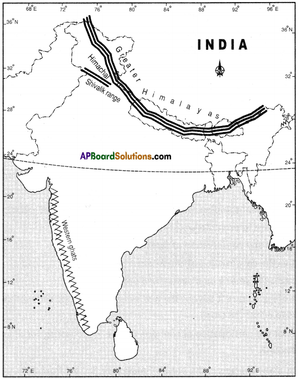
Question 2.
Using the colour code, identify the height range in which some of the rivers originate. Using the atlas and the raised relief map, follow the course of these rivers and locate the direction in which they are flowing.
Answer:
Some of the rivers : Indus, Brahmaputra, Ganga, Krishna, Godavari, Narmada and Tapati.
| Sl.No. | River | Height range of origin | Direction |
| 1 | Indus | 1001 to 3000 mts | Westward |
| 2 | Brahmaputra | 1001 to 3000 mts | Eastward |
| 3 | Ganga | Above 3000 mts | Southward and then eastward |
| 4 | Krishna | 1001 to 3000 mts (Mahabaleswar) | Eastward |
| 5 | Godavari | 1001 to 3000 mts | Eastward |
| 6 | Narmada | 301 to 1000 mts | Westward |
| 7 | Tapati | 301 to 1000 mts | Westward |
![]()
Question 3.
Discuss: About 5% of water is used for domestic purposes and yet a large section of the population does not have access to the water.
Answer:
- Out of the total water available, most is saline and only less than 3% is non-saline.
- Most of it is in the form of ice and only less is accessible.
- Out of this available water also only 5% is used for domestic purpose and the remaining is used for other purposes.
- In spite of all this, a large section of the population does not have access to water.
- There are many reasons for this like the depletion in groundwater tables.
- Non-domestic usage is geared up with bore/tubewells and pumps and extracting a large amount.
- The poor and destitute do not have access to water.
- Water supply is a state responsibility under the Indian constitution.
- In some coastal areas, sea water desalination is becoming an important source of drinking water supply.
- There is a need to river linking in India.
Question 4.
40 million hectares of land in India is flood-prone and an equally large part of the country is also drought prone. What are the causes of this ?
Answer:
- In India only 40% of the cultivated land has irrigation facility.
- For the remaining cultivated land, agriculture is the gambling with monsoon.
- If monsoons give good rains, the year is good otherwise most part is drought-prone.
- In India there are 72 drought – prone districts spread over 13 states.
- Floods mostly occur in the low-lying plain areas and river valleys almost every year in the country.
- 40 million hectares of land in India is flood prone.
- We have no interlinking of rivers in India, which can arrange for the transfer of floodwaters to drought-prone areas.
- Thus we are equally affected with both floods and droughts.
- Floods are associated with excessive rainfall while droughts are the result of deficit rainfall.
- Hydrology, deforestation, soil nature and erosion also play an important role in these
calamities.
![]()
Question 5.
70% of our surface water resources are polluted. Why?
Answer:
- The contamination of water with unwanted and harmful substances is called water polution.
- The biodegradable waste enters a water supply and thus pollutes water.
- Chemical fertilisers from agriculture runoff due to rain and industrial waste pollute water.
- Heat can be a source of pollution in water by decreasing the amount of dissolved oxygen.
- Sediment consists of mineral or organic solid matter that is washed from land into water sources.
- The industrial waste contains a large number of harmful chemicals like acids, alkali and metals such as arsenic, lead, mercury and cadmium leading to toxicity.
- Hazardous substances like fluorine mixed in groundwater are causing pollution.
- Thus nearly 70% of the surface water sources are polluted.
10th Class Social Textbook Page No. 59
Question 6.
With the help of an atlas trace the course of Indus both in India and Pakistan.
Answer:
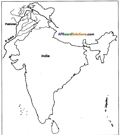
Out of the total length of 2880 kms Indus flows 709 kms in India and 2171 kms in Pakistan.
![]()
Question 7.
Look at the map of river Ganga and name the states which are drained by it.
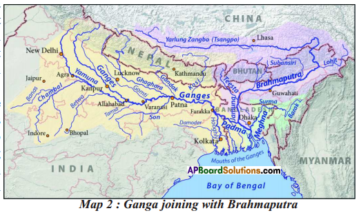
Answer:
The states which are drained by the river Ganga are Uttarakhand, Uttar Pradesh, Bihar, West Bengal, Madhya Pradesh, Haryana and Rajasthan.
Question 8.
From the above map list out the north-flowing and south-flowing tributaries of the Ganga. North-flowing tributaries of the Ganga :
Answer:
- The Yamuna
- The Gomti
- The Ghaghara
- The Gandak
- The Kosi
- The Teesta
South-flowing tributaries of the Ganga :
- The Chambal
- The Sind
- The Betwa
- The Ken
- The Son.
10th Class Social Textbook Page No. 60
![]()
Question 9.
From the Map and using your atlas, describe the following.
- The Godavari originates in ——– and ——–.
- The Krishna is the second largest east flowing peninsular river which rises near ——–.
- The Mahanadi rises near Sihawa in Chattisgarh and runs through ——–.
- The Narmada originates near ——– in Madhya Pradesh.
- The Tapati originates from ——– and flows ——– (fill in the direction of flow).
Answer:
- Triambak plateau drains into Bay of Bengal
- Mahabaleswar
- Odisha
- Amar Kantak
- Multai; westward
10th Class Social Textbook Page No. 61
![]()
Question 10.
Discuss the term “watershed”.
Answer:
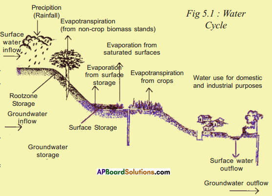
- Watershed is a line of high land where streams on one side flow into one river and streams on the other side flow into a different river.
- If the flow of water (rain water) were to be checked by vegetation or bunds, then there would be a greater possibility of the water percolating into the soil to join the groundwater.
- Over the last few years great efforts have been undertaken to harvest rainwater by these means.
- These measures are usually taken for a stream or a river.
- Such efforts are called ‘Watershed development projects’.
- Under these projects trees and grasses are planted on the hill slopes from where a stream starts and small bunds are built across streams to stop the flow of water.
Question 11.
From the nearest Mandal office find out the total annual rainfall for your area over the past 5 years.
Answer:
The total annual rainfall for the area of Mangalagiri over the past 5 years is as such.
| Year | (in cm.) |
| 2015 -16 | 130 |
| 2014 -15 | 140 |
| 2013-14 | 136 |
| 2012 -13 | 128 |
| 2011 -12 | 132 |
![]()
Question 12.
Recall from your science lessons what happens to the water that plants draw through their roots.
Answer:
- Plant absorbs water from the soil.
- The plant combines water and carbon dioxide with the help of sunlight to produce carbohydrates.
- Starch, sugars, cellulose are also carbohydrates.
- The plant does not use all the water it absorbs through its roots to produce carbohydrates, most of it evaporates into the air.
- The water that plants release into the atmosphere is called transpiration,
- Most of the water released by plants evaporate from the leaves, which have microscopic holes called ‘stomata’.
10th Class Social Textbook Page No. 63
Question 13.
On a map of India trace the course of the Tungabhadra river.
Answer:
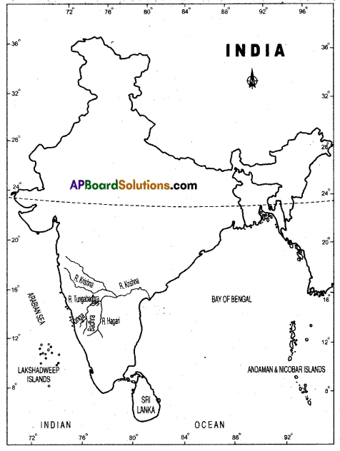
10th Class Social Textbook Page No. 65
![]()
Question 14.
How would it help if there was a government river basin authority for overall planning of water use?
Answer:
- Encroachment of public lands, by rampant felling of tree cover, brought under cultivation.
- It resulted in water run-off and flash floods.
- Storage capacity of dam was lost with accumulation of silt, dust, debris etc.
- Water is flow resource and its storage or use upstream affects what is available to people downstream.
- Growth of towns and industrial areas increased the demand for water.
- Conflicts within communities in a region and across sectors like agriculture, industry or drinking water are common.
- If there was a government river basin authority for overall planning of water use, all the problems above could be solved.
- If the government river basin is there it will solve the problems by following way.
a) It would do justice to all users of river basins water.
b) It would involve the community organisations in the authority.
c) It would reduce the growing conflicts and the possibility of social unrest in the country in future due to water scarcity.
d) It would rejuvenate the traditional techniques in conservation and management recognition of water as a common property resource.
Question 15.
What are the different conflicts in the use of water for Tungabhadra river basin ?
Answer:
- The basin of Tungabhadra, the tributary of Krishna, has two parts
a) the upper and middle catchment in Karnataka,
b) the lower portion of the catchment in Telangana and Andhra Pradesh. - There is a lot of difference in water availability between these two types of regions.
- Conflicts between Karnataka, Telangana and Andhra Pradesh are generally related to water
that is available to use. - Water is a flow resource and its storage or use upstream affects what is available to people downstream.
- Water is shared based on agreements between state governments.
- Although the area is ideal for semi-arid crops, the major crops grown demand a lot of water.
- Cultivation of such crops throughout the basin has dramatically altered the water sharing balance.
- When all areas desire water for these crops, conflicts become inevitable.
(OR)
- Tunga bhadra is the major tributary of the river Krishna.
- Tungabhadra project was constructed and it was the joint venture of Karnataka, Telangana State and A.P.
- The upper catchment area is used for storage by water harvesting. The lower portion of the basin is characterised by lower rainfall and drought conditions.
- Later Karnataka constructed another dam known as Almatti dam.
- The height and the water storage capacity of the river is the apple of discard among Karnataka, Telangana and A.P.
- Tribunals have given judgements on the water sharing proportions among Telangana state, A.P and Karnataka.
- But still it is a burning water dispute among these states.
10th Class Social Textbook Page No. 67
![]()
Question 16.
Underline sentences that reflect the efforts taken for water conservation in Hiware Bazar.
Answer:
- Most significant was the ban on borewells for irrigation, growing sugarcane and banana and selling one’s land to any outsider.
- The most significant development is that increased water availability has made a second crop possible due to normal rainfall.
- Social control over groundwater extraction and use no borewells for irrigation (only for drinking water) no water-intense crops like sugarcane.
- Water for irrigation should be taken only through due wells.
- They keep rainfall data meticulously and use it for crop planning and water use prioritisation.
- As they plan according to water available there was no shortage of water to drink even in years of continuous drought.
Question 17.
What was the effort for planning agriculture according to the available water ?
Answer:
- Farmers of Hiware Bazar worked out certain thumb rule type of think like if they get good rainfall, then they can take full Rabi crop.
- If the rainfall is less then they bring down the area under rabi etc.
- They keep rainfall data meticulously and use it for crop planning and water use prioritisation.
- Because of this even in years of continuous drought there was no drinking water shortage.
- This is mainly because they plan according to the water available.
Question 18.
If you have access to internet, watch a documentary about Hiware Bazar at http:// bit.ly/kothLl.
Answer:
Students’ Activity
10th Class Social Textbook Page No. 69
Question 19.
Should groundwater regulation be primarily community-led, as in the case of Hiware Bazar ?
Answer:
- Groundwater regulation in Hiware Bazar was taken up by community and saw good results.
- But it definitely may not be the same if it were primarily led by community throughout the country.
- Instead of that, governments should bring new laws and rules in place of the existing ones and serve the purpose.
- They should make the water as common pool resource and identify the human right for water.
- Drinking water shall be given the first priority.
- Panchayat Raj institutions must be given control over the use of groundwater.
- Governments shall not encourage over use or over extraction of underground resources of water.
- So the governments must take up the responsibility instead of community.
![]()
Question 20.
“The groundwater laws are both outdated and inappropriate.” Explain.
Answer:
- The current laws about groundwater in many states are both outdated and inappropriate.
- They were developed at a time when groundwater was a marginal source of water.
- Today shallow and deep tubewells have the potential to draw a lot of water.
- Now the basic link between access to groundwater and land ownership on which the rules are based are flowed.
- Land owners were not restricted in the amount of water they can take out.
- Over extraction from one tubewell often dries up other tubewells around.
- Moreover, there are no laws and regulations that can determine on how many wells, hand pumps and other tubewells can be sunk in a given area.
- Some support that groundwater is a public resource and some others support the primacy of land owners control over ground water.
- Hence laws are outdated and have to be modified.
Question 21.
Should groundwater be considered a common pool resource ? Explain your view.
Answer:
- For resource like water, the consumption by one person or a sector affects what is available to others.
- In a number of states, the answer to falling water tables has been not to address the issue itself.
- Apart from this each person wants their share of water before someone else.
- This is the real contemporary challenge.
- So groundwater should be considered a common pool resource.
- Based on this the laws and rules to water usage should be framed.
- It should be made that drinking water is the first priority as well as a human right.
- Panchayat Raj institutions must have control over the use of groundwater.
(OR)
- Over the past few decades ground water has been the main source, especially for domestic use and agriculture.
- This tremendous increase in the use of ground water has a significant impact on water availability and on access to water.
- Water is a flowing resource. Extraction from one tube well often dries up other tube wells around.
- If each one competes to go deeper than the neighbour, the ground water structure would be disturbed.
- Hence ground water should be considered as common pool resource and we should delink the connection between the ownership of land and water drawn from the underground.
![]()
Project work
Think of plans for your village or locality, which if implemented would help everyone.
Answer:
Students’ Activity.