SCERT AP Board 10th Class Social Solutions 4th Lesson Climate of India Textbook Questions and Answers.
AP State Syllabus SSC 10th Class Social Studies Solutions 4th Lesson Climate of India
10th Class Social Studies 4th Lesson Climate of India Textbook Questions and Answers
Improve your learning
Question 1.
Read the following statements and mark if It is an example of weather or climate.
(a) During the last few years many glaciers have melted in the Himalayas.
Answer:
It is an example of weather.
(b) During the last few decades drought in the Vidarbha region has increased.
Answer:
It is an example of climate.
![]()
Question 2.
Match the following. Use maps if you cannot locate the places.
(There could be multiple correct answers.)
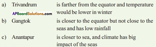
Answer:
(a) Trivandrum — is closer to sea and the climate has big impact of the seas
(b) Gangtok — is farther from the equator and temperature would be lower in winter
(c) Anantapur — is closer to the equator but not close to the seas and has low rainfall
Question 3.
Describe India’s climate controls.
(OR)
Explain any two factors that influence the climate in India.
Answer:
The factors that affect climate are called climatic controls. These include:
- Latitude
- Land – Water relationship
- Relief
- Upper air circulation.
1. Latitude:
- The intensity of temperature depends on the latitude. It is more intense in lower latitudes than at higher latitudes.
- In India, the Southern part lies ¡n the tropical zone, closer to the equator; it has higher average temperature than the northern part.
2. Land – Water relationship:
- The water bodies absorb and losses heat more slowly than land.
- Due to this the formation of land and sea breezes influence the climate of coastal region.
3. Relief:
- Relief or altitude of a region influences the climate of the area.
- Several hill stations have cool climate even during summer months.
Eg: Simia, Nainital, Mussone, Kodaikanal.
4. Upper air circulation:
- The high velocity of Upper air movements is known as “Jet Streams’.
- This jet stream causes the neighboring atmosphere to cool.
![]()
Question 4.
Write a short note on factors influencing climatic variations in hilly areas and deserts.
Answer:
- The factors influencing climatic conditions are called climatic controls.
- These include (i) Latitude (ii) Land-water relationship (iii) Upper air circulation.
- In hilly areas important factors influencing climatic conditions are latitudes, relief and land- water relationship, and upper air circulation only as a whole.
- If the hills are in southern India, they receive more temperature and rainfall. If they are near the coast, the effects would be different.
- In the hilly area altitude also plays a crucial role in deciding the temperature in accordance with the normal lapse rate.
- Relief of desert plays a crucial role in its temperature being decided and the inland nature shuns any influence of land-water relationship.
- The rainfalls in these regions are scanty and during temperature range is very high.
Question 5.
How are human activities contributing to global warming?
Answer:
- Human activities contribute to climate change by causing changes in Earth’s atmosphere in the amounts of greenhouse gases, aerosols and cloudiness.
- The largest known contribution comes from the burning of fossil fuels, which releases carbon dioxide gas to the atmosphere.
- Greenhouse gases and aerosols affect climate by altering incoming solar radiation and outgoing infrared radiation that are part of the earth’s energy balance.
- Changing their atmospheric abundance or properties of these gases and particles can lead to a warming or cooling of the climate system.
- Since the start of the industrial era (about 1750) the overall effect of human activities on climate has been a warming influence.,
- The human impact on climate during this era greatly exceeds that due to known changes in natural processes such as solar changes and volcanic eruptions.
![]()
Question 6.
What are the disagreements between ‘developed’ and ‘developing’ countries about AGW ?
Answer:
- An international organization called the Inter-governmental Panel on Climate Change (IPCC) was formed to reduce the emission of greenhouse gases.
- The latest attempt made at the IPCC conference in Warsaw (Poland) in 2013, failed to achieve any agreement.
- Disagreements are between developed countries and developing countries.
- Developed countries want developing countries to cut down on burning coal and other activities that add greenhouse gases to the atmosphere.
- Developing countries argue that developed countries developed precisely by burning fossil fuels in their development and their economic development will be seriously (developing countries) damaged if (developing countries) they do not burn fossil fuels.
- Developing countries also argue that developed countries should do their fair share of work to find alternatives that can help the developing countries to progress.
Question 7.
How is climate change causing global warming? Suggest measures to minimise the influence of the global warming.
Answer:
- Now heating of earth is much more rapid and could lead to catastrophic changes.
- Much of the warming has been occurring since the Industrial Revolution.
- Volumes of methane under the frozen tundras of northern latitudes is discovered.
- As global temperature increases, the ice in the tundra melts more.
- The methane trapped in, the ice escapes into the atmosphere increasing global temperatures.
- In turn, this causes even more ice to melt, releasing more methane, and so on.
- To minimize the influence of global warming, we should plan to reduce the emission of greenhouse gases like CO2, Methane, etc.
- We should take up afforestation.
- We should encourage public transport.
- We should minimize the use of refrigerators and air conditioners, etc.
![]()
Question 8.
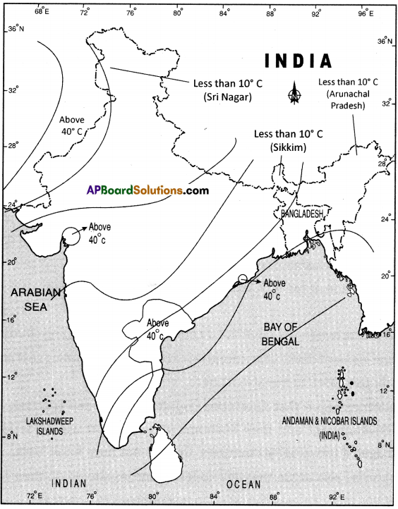
On an outline map of India, show the following:
(i) Areas recorded with more than 40°C annual mean temperature.
(ii) Areas recorded with annual mean temperature less than 10°C.
(iii) The direction of the south-west monsoon over India.
Answer:
Question 9.
Observe the following climograph and answer the following questions.
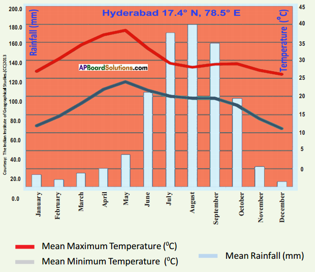
![]()
(A) Which month received the highest rainfall?
Answer:
‘August’ month received the highest rainfall.
(B) Which months experience the highest and the lowest temperature?
Answer:
The highest temperature is experienced in the month of May.
The lowest temperature is experienced in the month of December.
(C) Why is the maximum amount of rainfall between June and October?
Answer:
The maximum amount of rainfall is received in Hyderabad between the months of June and October. The reason for this is the presence of south-west monsoons.
(D) Why is the temperature high between March and May?
Answer:
The temperature is high between March and May because it is the summer season.
(E) Identify relief conditions causing variation in temperature and rainfall.
Answer:
Hyderabad is present in the Deccan Plateau. It is situated at an elevation of 600 m from the mean sea level.
10th Class Social Studies 4th Lesson Climate of India InText Questions and Answers
10th Class Social Textbook Page No. 45 & 46
Question 1.
Fill the table after reading climographs.
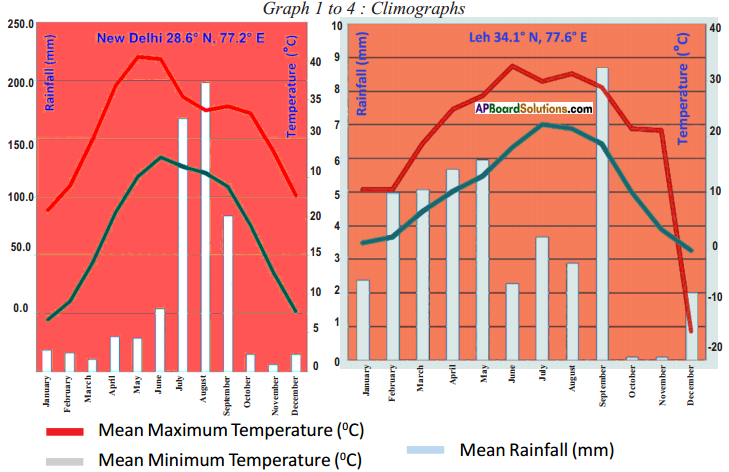
Range of Temperature: From highest value to lowest value
 Answer:
10th Class Social Textbook Page No. 46
![]()
Question 2.
What are the warmest and coldest months in Leh?
Answer:
The warmest month in Leh is June The coldest month in Leh is January.
Question 3.
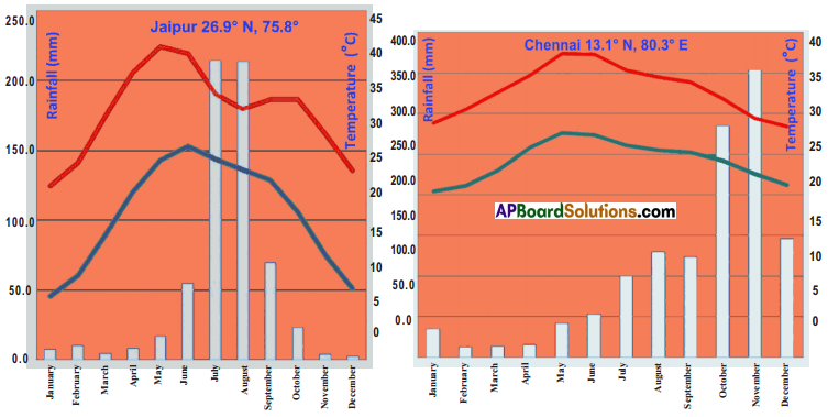
From the range of temperatures in the above table, say whether Jaipur is, in general, hotter than Leh. Explain your answer.
Answer:
- Jaipur is, in general, hotter than Leh.
- In the hottest month, Leh got 26°C the highest temperature whereas Jaipur got 40-C during the same month.
- Thus, we can say Jaipur is hotter in general.
Question 4.
Compare the climate of Delhi and Chennai. How are they different? 4S June 20171
Answer:
- Delhi has an extreme climate with 6°C as the lowest temperature and 40°C as the highest temperature.
- Every month the difference between the highest and lowest temperatures is also more around 16°C.
- But whereas Chennai has a moderate climate with 38°C as highest and 20°C as the lowest temperature.
- Even the difference between the highest and the lowest every month is also less, around 10°C.
- Delhi The climate of Delhi is a monsoon-influenced humid subtropical with high variation between summer and winter temperatures and precipitation. Its climate is greatly influenced by its proximity to the Himalayas and the Thar Desert, causing it to experience both weather extremes.
- Chennai: The geographical location determines the weather and climate in Chennai. The close proximity of the ocean and equator makes the climate and weather in Chennai relatively consistent with less variation in the seasonal temperature. The weather in Chennai is mostly hot and humid.
![]()
Question 5.
Read carefully the rainfall pattern for Leh. In what ways is this different from the others? From your atlas, can you find out some other places in the world that have similar rainfall patterns?
Answer:
- Leh is situated nearly 6 km above the mean sea level.
- So the atmosphere there is not conducible for rain.
- It receives less than 10 mm as the maximum monthly rainfall.
- The remaining three places receive 200 mm or more rainfall as the maximum monthly rainfall.
- It is surrounded by greater Himalayan mountains which are always covered with snow.
- Thus, it is different from the other 3 places which are unlike this.
- There are some other places in the world like this like Zurich in Switzerland, Oslo in Norway, Thimpu in Bhutan and Khatmandu in Nepal etc.
Question 6.
Identify the wet months for Chennai. How is this different from Jaipur?
Answer:
- The wettest months for Chennai are October and November.
- It is because it receives rainfall during the retreat of southwest monsoon or during the north-east monsoon.
- Whereas the wettest months for Jaipur are July and August.
- It receives rainfall during the southwest monsoon.
- In this way Chennai and Jaipur are different.
10th Class Social Textbook Page No. 47
Question 7.
Using a globe recall and discuss what you may have read earlier. How does the angle of the sun vary at different latitudes? What impact does this have?
Answer:
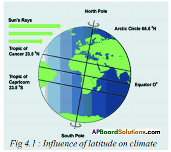 Sun angles and their impact.
- Tilt of the earth is the axis of rotation.
- Axis of rotation tilted 23.5° away from perpendicular to the plane of earth’s orbit.
- Due to this, it creates seasonal variations in which hemisphere is oriented towards the sun.
![]()
10th Class Social Textbook Page No. 48
Question 8.
In your atlas, compare the temperatures of Mumbai and Nagpur for the winter and summer months. How are they similar or different? How does it explain the distance from the sea?
Answer:
- Mumbai is located on the west coast at 18°55′ N latitude and 77°54′ E longitude.
- Nagpur is located as an inland at 21°9′ N latitude and 79°9′ E longitude.
- For January, the winter month Mumbai has an average temperature of 24.4°C whereas Nagpur has 20.6°C.
- For May, the summer month Mumbai has an average temperature of 30°C whereas Nagpur has 37°C.
- As Mumbai is on the west coast it is experiencing a moderate climate with less changes of temperatures.
- Being an island region, the variations in temperatures during summer and winter are more for Nagpur.
- Thus, It shows the influence of distance from the sea.
Question 9.
With the help of the climographs, can you explain how differences in temperature can be explained for Jaipur and Chennai ?
Answer:
- Jaipur has an extreme climate whereas Chennai is with moderate climate.
- Though the highest average temperature for both regions are at near 40*C, the lowest average temperatures for Jaipur is at 6°C whereas that is for Chennai is 18°C.
- The monthly differences in highest and lowest temperatures also vary.
- For Jaipur they are around 16°C whereas for Chennai they are around 10°C.
- The atmosphere of Chennai will be pleasant with these temperatures whereas that is not the case with Jaipur.
![]()
Question 10.
Are Shimla and Delhi located on very different latitudes? Check with your atlas. Is Shimla cooler than Delhi during summer ?
Answer:
- Delhi is located at 28°38’N latitude and 77°17’E longitude.
- Shimla Is located at 31°6’N latitude and 77°13′ E longitude.
- Thus Delhi and Shimla are located in different latitudes.
- During summer Shimla is cooler than Delhi.
- Being in the northern plain and experiencing the hot winds named ‘Loo’ Delhi experiences high temperatures, during summer.
- Being in the Himalayan ranges and above the altitude of more than 3 km Shimla experiences less temperatures compared to Delhi, during summer.
Question 11.
Why does Darjeeling have pleasant weather as compared to Kolkata during summer season ?
Answer:
- Darjeeling is located in West Bengal at the latitude of 27°3′ N and a longitude of 88°18′ E.
- Kolkata is also located in West Bengal at the latitude of 22°34′ N and a longitude of 88°24′ E.
- Kolkata is located near the coast and experiences the advantage of the nearness to water during summer.
- But Darjeeling, being situated in the Himalayan Ranges at an altitude of more than 3 km, experiences less temperatures during summer.
- Thus, Darjeeling will have pleasant weather compared to Kolkata during the summer season.
10th Class Social Textbook Page No. 49
Question 12.
What would be the range for the average temperature in A.P. for January?
Answer:
- January is the month during which winter is severe.
- It usually will be cold during this month throughout Andhra Pradesh.
- For the month of January, the average maximum temperature is around 28°C.
- The average minimum temperature is around 16°C for January in Andhra Pradesh.
- Thus range of average temperature for January in Andhra Pradesh is around 28°C to 16°C.
Question 13.
Using your atlas, find some places located on 15°C temperature.
Answer:
The places that are located on 15°C are Jaipur, Mathura, Itanagar etc.
![]()
Question 14.
Close to the line showing places where average temperature is 25°C, there’s a small circle of places on 20°C. How is this possible?
Answer:
- Close to the line showing places where average temperature is 25°C, there is a small circle of places on 20°C.
- That is the region where the Western Ghats rise above 2000 m peaks.
- There are the Nilgiri Hills which has peaks more than 2000 m height.
- So the temperatures there are less as the elevation is more.
- That is why there was 20°C circle close to 25°C line.
10th Class Social Textbook Page No. 50
Question 15.
From the climographs (Graph 1-4), note the approximate average temperature for May for the four places and mark them on the map given.
Answer:
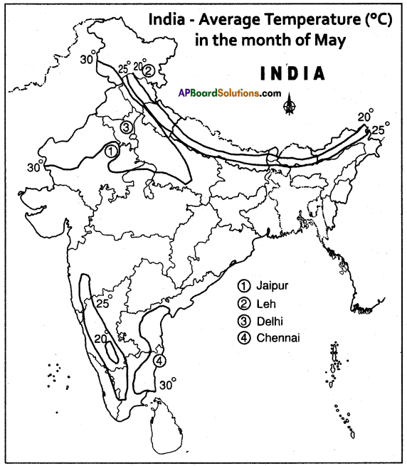
- Jaipur 24°C to 40°C
- Leh 12°C to 29°C
- New Delhi 34°C to 40°C
10th Class Social Textbook Page No. 54
![]()
Question 16.
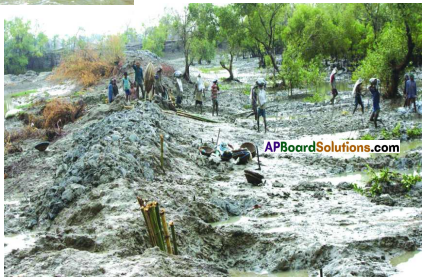
What is deforestation ?
Answer:
- Cutting down of the trees indiscriminately in the areas of forest or where there a presence of sizable number of trees like plantations is called deforestation.
- It results in the lowering of the green cover.
- It affects the ecological balance.
- It reduces the probability of raining.
- It affects the soil erosion, it increases soil erosion.
- It also affects the sustainability of green cover.
Question 17.
Does deforestation happen only in forest areas? How about in your local area, even if there are no forests?
Answer:
- Deforestation not only happens in forest areas.
- In our local areas the felling of trees comes under deforestation.
- Even if there are no forests, the cutting down of trees is considered as deforestation.
Question 18.
How does deforestation affect global warming?
Answer:
- Deforestation is the cutting down of trees for commercial purposes (other than domestic purposes of tribals) in the forests and vegetations of a large scale.
- Trees make use of the most of the greenhouse gas of carbon dioxide into their food which is called photosynthesis using sunlight.
- If trees were cut down indiscriminately, it would result in the accumulation of C02, the green house gas.
- It will result in the increase of temperatures throughout the earth i.e., global warming.
- Thus, deforestation affects global warming.
![]()
Question 19.
What are some other ways in which human action contributes to global warming?
Answer:
- Usage of refrigerators and air conditioners, etc. by humans leads to global warming.
- Usage of motor vehicles which run on fuel emits greenhouse gases.
- Usage of inorganic fertilizers, chemicals and pesticides.
- Releasing of effluences and wastes of industries.
- Excessive usage of natural resources.
10th Class Social Textbook Page No. 55
Question 20.
Imagine how one would cope with the situation if millions of people were affected. Where would you find land for resettlement? What jobs would they do?

Answer:
- If millions of people were affected with any natural calamity, it certainly would be difficult to cope with.
- The government has to make arrangements to resettlement of all those affected.
- It may seek help from international organisations or non-governmental organisations in our country as well as the donors.
- It will be a Herculean task to provide them shelter and alternate employment, but government must take initiative to get it done.
- It must employ the eligible to work within Rural Works Programme, Food for Work, Mahatma Gandhi National Rural Labour Employment Guarantee schemes etc.
![]()
Project work
Collect proverbs/sayings that are related to climate and weather in your region.
- A Rainbow in the morning is the Sailor’s Warming.
- A Rainbow at night is the Sailor’s delight.
- When the dew is on the grass rain will never come to pass.
Answer:
“Red sky at night, sailor’s delight. Red sky in the morning, sailor take warning.”
“Mare’s tails and mackerel scales make tall ships take in their sails.”
“Clear moon, frost soon.”
“Halo around the sun or moon, rain or snow soon.”
“Rainbow in the morning gives you fair warning.”
“When the stars begin to huddle, the earth will soon become a puddle.”