SCERT AP Board 10th Class Social Solutions 1st Lesson India: Relief Features Textbook Questions and Answers.
AP State Syllabus SSC 10th Class Social Studies Solutions 1st Lesson India: Relief Features
10th Class Social Studies 1st Lesson India: Relief Features Textbook Questions and Answers
Improve your learning
Question 1.
The sun rises two hours earlier in Arunachal Pradesh as compared to Gujarat in the west. But the clocks show the same time. How does this happen?
Answer:
- The sun rises two hours earlier in Arunachal Pradesh as compared to Gujarat.
- It takes 4 minutes for the sun’s position to move one longitude.
- This means that the time is different for each degree of longitude.
- Based on the longitudes the time is calculated.
- Then two different places in our country will have different times, which cause a lot of confusion.
- To avoid this confusion of time from place to place 82°30’ E longitude is taken as the standard meridian of India and serves as Indian Standard Time.
- All people in India have to follow this time. Thus clocks show the same time.
![]()
Question 2.
If the Himalayas would not have been in its present position, how would be the climat conditions of the Indian sub continent?
(OR)
What is the geographical impact of the Himalayas in influencing the Indian climate?
Answer:
- The formation of the Himalayas influences the climate in various ways.
- These act as barriers protecting the great plains of India from the cold winds of central Asia during winter.
- The Himalayas are reason for summer rains and monsoon type climate in regions that are beyond the Western Ghats of India.
- In its absence, this region would have remained drier.
- India would have been a tropical desert.
Question 3.
The Himalayas do not extend into which of the following states :
Madhya Pradesh, Uttar Pradesh, Sikkim/Haryana, Punjab, Uttaranchal.
Answer:
- The Himalayas run in the west-east direction in the form of an arch with a distance about 2400 kms.
- These have extended into states like Jammu and Kashmir, Himachal Pradesh, Nagaland, Manipur and Meghalaya in India.
- These do not extend into Madhya Pradesh, Uttar Pradesh, Haryana and Punjab.
![]()
Question 4.
Which are the major physiographic divisions of India? Contrast the relief of the Himalayan region with that of the peninsular plateau.
Answer:
- There are six major physiographic regions of India.
- They are:
- The Himalayas,
- The Indo-Gangetic plain,
- The Peninsular Plateau,
- The Coastal Plains
- The Thar Desert and
- The Islands.
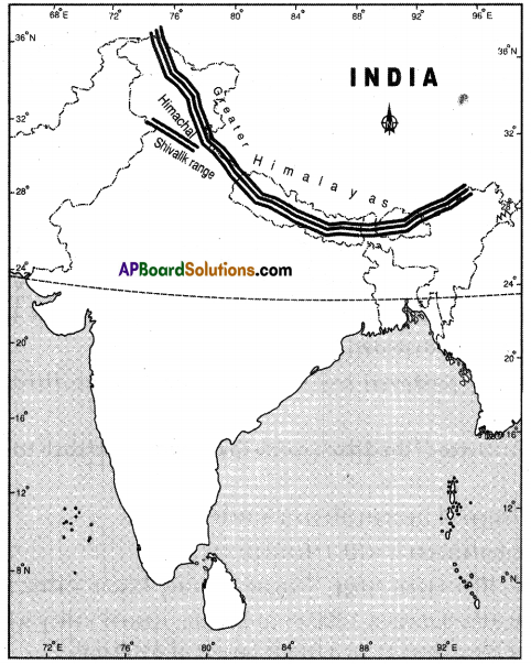
- The Himalayas have 3 ranges of mountains. Among them Himadri has the highest peaks with an average elevation of about 6100 mts above the mean sea level.
- In ‘Lesser Himalayas’ the height of the peaks ranges between 3700 to 4500 mts.
- Shivaliks have an altitude varying between 900 mts and 1100 mts.
- The Himalayas width differs from 500 kms, in the western regions to 200 kms in central and eastern regions.
- The peninsular plateau consists of two broad divisions namely, the central high lands (Malwa Plateau) and the Deccan Plateau.
- The place where the Western Ghats and Nilgiris meet has many peaks over a height about 2000 mts.
- The average height of the Eastern Ghats rarely exceeds 900 mts.
- The highest peak in the Eastern Ghats is Aroma Konda found at Chintapalli in Andhra Pradesh.
Question 5.
What is the influence of the Himalayas on Indian agriculture?
(OR)
How do the Himalayas influence agriculture in India?
Answer:
- The formation of the Himalayas influences the climate in various ways.
- They are the reason for summer rains and monsoon type of climate in regions that are beyond the Western Ghats of India.
- They cause the retreat of southwest monsoon winds as they are blocked by these ranges.
- Thus, northeast monsoon occurs only because of the Himalayas.
- The rivers originating in the glaciers of these ranges are perennial and caused the economic growth of the northern plains.
- These valleys are known for the cultivation of fruits.
- India has irrigation facilities only for 40% cultivated land.
- All the remaining land depends on monsoons which are caused by the Himalayas.
(OR)
Answer:
Influence of the Himalayas on Indian Agriculture:
- Fertile soil: The sediments carried by the Himalayan rivers are deposited in the northern plain in the form of fertile soil. It makes the plain one of the most fertile lands in the world, e.g.: Bhabar, Terai, Bhangar.
- Source of rivers :
- The Himalayas act as a huge reservoir of water for the north Indian rivers.
- All these perennial rivers are the lifeline of north India and are suitable for the construction of multipurpose projects which strengthens Indian agriculture.
![]()
Question 8.
Use an atlas and identify the following:
i) The Islands formed due to Volcanic eruption.
ii) The countries constituting Indian Subcontinent.
iii) The states through which the Tropic of Cancer passes.
iv) The northernmost latitude in degrees.
v) The southernmost latitude of the Indian mainland in degrees.
vi) The eastern and the westernmost longitudes in degrees.
vii) The place situated on the three seas.
viii) The strait separating Sri Lanka from India,
ix) The Union Territories of India.
Answer:
i) Narcondam and Barren Islands.
ii) India, Pakistan, and Bangladesh.
iii) Gujarat, Rajasthan, Madhya Pradesh, Chattisgarh, Jharkhand, West Bengal, Tripura and Mizoram.
iv) 37°6′
v) 8°4′
vi) 97°25′ Easternmost longitude; 68°7’Westernmost longitude
vii) Tamil Nadu
viii) Palk strait
ix) Delhi, Chandigarh, Diu Daman, Dadra, and Nagar Haveli, Pondicheri, Andaman and Nicobar Islands and Lakshadweep Islands.

Question 9.
How are the Eastern coastal plains and Western coastal plains similar or different?
Answer:
| Eastern Coastal Plains | Western Coastal Plains |
| 1. These are wide and have large surface structure. | 1. These are narrower than the east coast. |
| 2. Stretch from Mahanadi to Cauvery delta. | 2. These are uneven and broken by hilly terrain. |
| 3. Known locally by different names : Utkal coast (Odisha), Circar coast (Andhra Pradesh), Coromandel coast (Tamil Nadu). | 3. The southern part of peninsular plateau is bordered by narrow strip along the Arabian Sea. |
| 4. These formed by rivers Mahanadi, Godavari, Krishna and Cauvery and are very fertile. | 4. These start from Rann of Kutch and end at Kanyakumari. |
| 5. These deltas are agriculturally developed. | 5. It is divided into three parts. |
| 6. Coastal zone also enables rich fishing resources. | 6. Konkan coast – this is the northern part. It touches Maharashtra and Goa. |
| 7. Lakes like Chilka in Odisha and Kolleru and Pulicot (Andhra Pradesh) are other important features of the coastal plain. | 7. Canara coast – this is the middle part includes coastal plains of Karnataka. |
| – | 8. Malabar coast – this is the southern part, mostly in the state of Kerala. |
![]()
Question 10.
Plateau regions in India do not support agriculture as much as the plain regions -what are the reasons for this?
Answer:
- Plateau regions in India do not support agriculture as much as the plain regions.
- There are many reasons for this.
- The physical formation of plateau is not much supportive to agriculture.
- Plains are formed with alluvial soils which are very fertile, so support agriculture.
- The rugged surface of plateau makes irrigation difficult whereas plains provide much irrigation facilities.
- Plateau region does not have any perennial river, whereas plain regions have perennial rivers.
- Plateau region is rich in mineral resources whereas plains are rich in agriculture practice.
10th Class Social Studies 1st Lesson India: Relief Features InText Questions and Answers
10th Class Social Textbook Page No.1
Question 1.
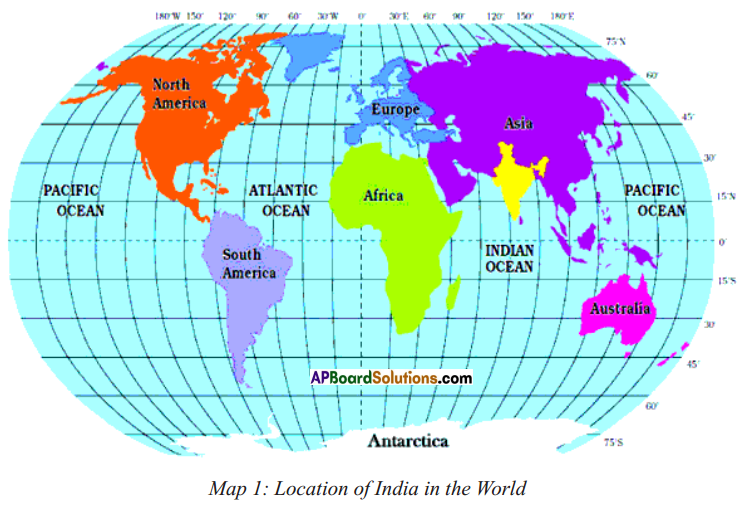 Look at the world map given above, and write a few lines about India’s location with reference to the places marked on this map.
Answer:
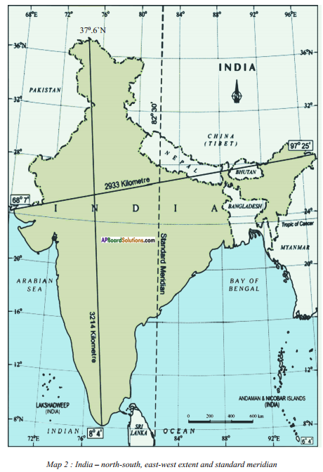
India is located to the north of the equator between 8°4′ and 37°6′ north latitudes and 68°7′ and 97025′ east longitudes.
![]()
Question 2.
The lines of latitude and longitude are used for accurately specifying the location of any place or region. Use the atlas and correct the following statement:
“India is a very extensive country and lies totally in the southern Hemispheres of the globe. The country’s mainland lies between 8 degrees N and 50 degrees N longitude and 68 degree S and 9 degrees E latitude.”
Answer:
India is a very extensive country and lies totally in the Northern hemisphere and the Eastern hemisphere of the globe. The country’s mainland lies between 8°4′ and 37°6′ North latitude and 68°7 and 97°25′ East longitude.
10th Class Social Textbook Page No. 2
Question 3.
Why do we often use the term “Indian peninsula”?
Answer:
- Any country which is surrounded by sea on three sides and the fourth side is landlocked, is called a peninsula.
- India is surrounded by the Bay of Bengal, the Indian Ocean, and the Arabian Sea as its three borders and the fourth side is landlocked with the Himalayan mountains.
- So we often use that term Indian peninsula.
Question 4.
Examine the map (Text Page No. 1) and imagine that India is located in the Arctic Circle. How would your life be different?
Answer:
If India is located in the Arctic Circle, my life would be different as follows :
- I must cope with very low temperatures and constant darkness in the winter, and temperatures above freezing and constant daylight in the summer.
- While temperatures are below freezing, snow and snow everywhere.
- Transportation: Sledges during winter and boards during summer.
- Diet: Fish, seals, wheals, caribou, berrys, plants.
- Shelter: Igloos are camps.
Question 5.
Identify Indira Point on the atlas. What is special about this? (OR)
What is special about ‘Indira Point’ with reference to the location of India ?
Answer:
- In Andaman and Nicobar Islands, Narkondam and Barren Islands are volcanic origin.
- The southernmost tip of India found in Nicobar Island is called Indira Point.
- It is named in honour of Smt. Indira Gandhi.
- It was submerged during the 2004 Tsunami.
![]()
Question 6.
Andhra Pradesh lies between and N latitudes and …… and E longitudes.
Answer:
Andhra Pradesh lies between 12I4T and 22° North latitudes and IT and 84°40′ East longitudes.
Question 7.
Using the scale given in your atlas estimate the length of the coast line for Andhra Pradesh?
Answer:
The length of the coast line for Andhra Pradesh is 972 kms or 604 miles.
Question 8.
Look at the map 2 on text page 3 and trace the boundary for India and colour this.
With the help of the scale given on the map, find out the total land boundary that India shares with Bangladesh.
 Answer:
The total land boundary that India shares with Bangladesh is 4,096.70 km.
Question 9.
Which of these data are for rising and setting times for the Sun at Ahmedabad and Imphal ?
Answer:
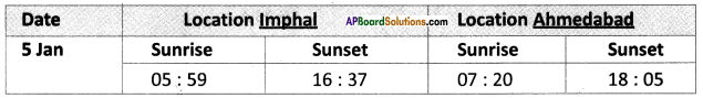
- Imphal is in the eastern side of India.
- The sun rises early there thus the sunrise timing of 5 :59 and sunset timing of 16 : 37 belong to it.
- Whereas Ahmedabad is in the western side of India.
- The sun rises late comparative to Imphal here, thus the sunrise timing of 7 : 20 and sunset timing of 18 : 05 belong to it.
10th Class Social Textbook Page No. 4
![]()
Question 10.
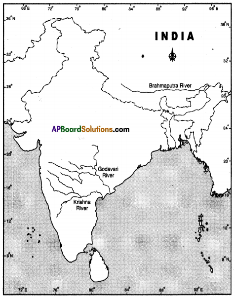
List the Himalayan rivers and the Peninsular rivers that helped the formation of North Indian Plain.
Answer:
The Himalayan rivers that helped the formation of North Indian Plain are
- Indus and its tributaries, the Jhelum, the Chenab, the Ravi, the Beas and the Sutlej.
- The Ganga and its tributaries, the Ghaggar, the Teesta, the Sone, the Kosi and the Yamuna river.
- The Brahmaputra and its tributaries.
- A majority of the tributaries of the Ganga may originate in the Himalayan ranges but some of them have their sources in the peninsular plateau.
- The peninsular rivers that helped the formation of Northern plain are the Chambal, the Sind, the Betwa, the Ken and the Son originating in the northern part peninsula belong to the Ganga river system.
Question 11.
The formation of the Himalayas was ———- million years ago while early hunter-gathering human beings emerged on earth ———— million years ago.
Answer:
200; 1.8
10th Class Social Textbook Page No. 5
Question 12.
Look at the Map 2 (on test page 3)and the raised relief map in your school. Using your finger trace the regions mentioned below:
a) Follow the course of Godavari and Krishna to identify the direction of slope of Deccan plateau.
b) Describe the entire course of the Brahmaputra River, with reference to landforms, heights, and countries.
Answer:
a) The direction of slope of Deccan plateau is West to East.
b) The course of Brahmaputra is with reference to
- Landforms: Lake, Himalayan range, Tibetan plateau, Assom Valley, Sunderban Delta.
- Heights: Mishmi Hills between 1000 m to 3000m, Assom Valley with a height upto 300 m, Greater Himalayas at an average height of 6100 mts.
- Countries: It flows through Tibet (China), India and Bangladesh.
![]()
Question 13.
Locate the three ranges in your atlas.
Answer:
1) Greater Himalayas or Himadri. 2) Lesser Himalayas or Himachal. 3) Shivaliks.
Question 14.
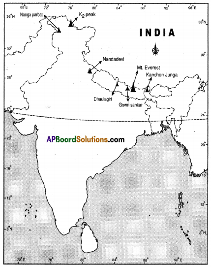
Locate some of the highest peaks in the raised relief map.
Answer:
Mt. Everest, K2 (Godwin Austin), Kanchenjunga, Gowrisankar, Nanga Parbat, Dhaulagiri and Nandadevi.
Question 15.
Trace with your fingers on the above regions (given in the text book matter) in the raised relief map and on the wall map with your fingers.
Answer:
Students’ Activity.
![]()
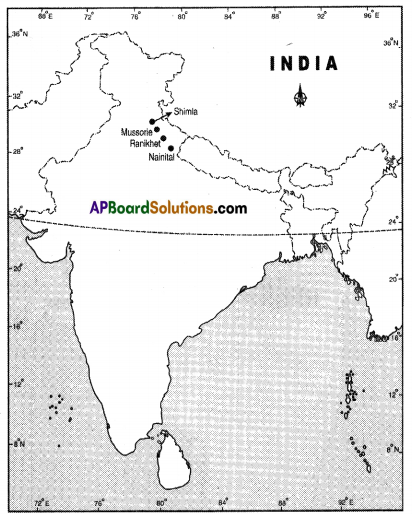
Question 16.
Locate the following places on Indian physical map in your atlas :
Shimla, Mussorie, Nainital and Raniket.
Answer:
10th Class Social Textbook Page No. 7
Question 17.
Locate the following ranges in the physical map of India.
Answer:
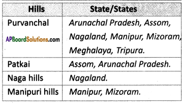
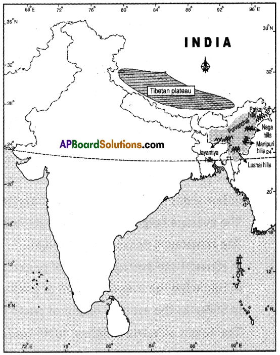
10th Class Social Textbook Page No. 9
![]()
Question 18.
Locate the following on the Indian physical map of your atlas and on the raised relief map: Malwa plateau, Bundelkhand, Bhagelkhand, Rajamahal Hills and Chotanagpur plateau.
Answer:
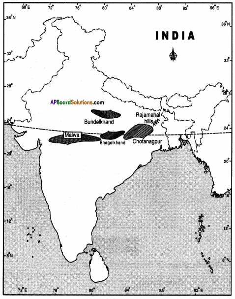
Question 19.
Using an atlas, compare the relative heights of above plateaus with that of Tibetan plateau.
Answer:
Tibetan plateau is higher than the peninsular plateau (Peninsular plateau 600 – 900 mts. height, Tibetan plateau – more than 5400 mts height).
10th Class Social Textbook Page No. 10
Question 20.
Look at the raised relief map and compare the relative heights of Western and Eastern Ghats as well as Tibetan plateau and Himalayan peaks.
Answer:
In few areas the average height of Western Ghats is more than 2000 mts.
The average height of Eastern Ghats rarely exceeds 900 mts.
The Himalayan peaks are of 3 ranges.
In Himadri the average height of peaks is 6100 mts.
In Himachal the average height of peaks is 4000 mts.
In Shivaliks the average height of peaks is around 1000 mts.
The height of world’s highest table land, the Tibetan plateau is above 5400 mts.
10th Class Social Textbook Page No. 12
Question 21.
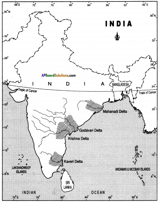
On the physical map of India identify the delta regions. How is their height similar or different ?
How do they compare in relation to the Indo-Gangetic Plains ?
Answer:
The height of these deltas is similar between 0 and 300 metres. The northern plain and deltas both are agriculturally developed.
Project work
Question.
Using the raised relief map, and physical maps in your atlas make clay/ sand models of India on the ground. Use different types of sand or soil to mark different types of relief features. Ensure heights of the places are proportional and rivers are marked. Look at the vegetation map in your atlas and try to use leaves and grasses to decorate them. May be over the year you can also add other features of India into them.
Answer: Students’ Activity.